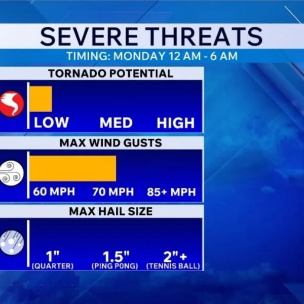
Paducah, Kentucky – Severe storms could quickly turn dangerous this evening, with wind gusts up to 70 mph and hail as large as 1.5 inches possible between 5 p.m. and 11 p.m.
According to the National Weather Service in Paducah, forecasters are confident that any storms developing during this window could become severe, even though overall coverage will remain limited. This means many areas may stay dry, but any storm that forms could intensify rapidly.
The highest risk area includes western Kentucky and southern Illinois, affecting communities such as Paducah, Murray, Mayfield, and Marion. Storms are expected to move from northwest to southeast, reaching southeast Missouri earlier in the evening before moving into western Kentucky between 7 p.m. and 11 p.m. Travel along I-24 and I-69 may face brief disruptions due to strong wind gusts and sudden heavy rain.
The tornado threat remains low, but it is not completely ruled out. The main concern is isolated storms capable of producing large hail and damaging straight-line winds that could bring down tree limbs and cause scattered power outages.
Residents should remain alert this evening, as warnings may be issued with little notice. The threat is expected to end late tonight, followed by quieter and warmer conditions through midweek.
Five-Day Forecast for Paducah, Kentucky:
Monday: Clouds increasing late, highs 54–61°F
Tuesday: Mix of sun and clouds, highs 61–67°F
Wednesday: Partly cloudy and warmer, highs 70–78°F
Thursday: 20–40% chance of evening storms, highs 82–89°F
Friday: 40–50% chance of showers and storms, highs 52–61°F


Leave a Reply