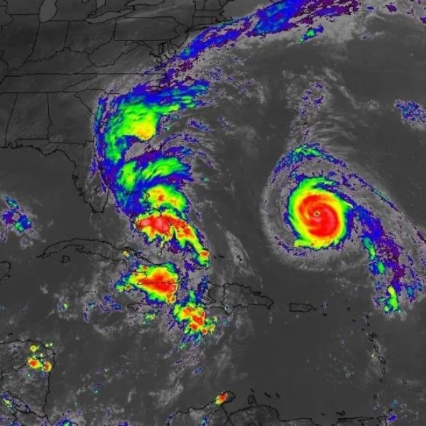
This satellite view from Sunday afternoon shows Hurricane Humberto on the right and Tropical Storm Imelda over the Bahamas.
Tropical Storm Imelda developed over the Bahamas Sunday afternoon and is expected to strengthen into a hurricane. While its forecast path now looks less threatening for the Southeast coast, the storm will still have an impact.
As of 8 p.m. ET Sunday, Imelda had maximum sustained winds of 40 mph and was located 335 miles southeast of Cape Canaveral, Florida, according to the National Hurricane Center.
Tropical storm warnings are in effect for the central and northwestern Bahamas, where the storm is dumping heavy rain. Rainfall totals could reach 4 to 12 inches in the Bahamas and eastern Cuba, enough to cause flash flooding.
Imelda’s forecast track has shifted away from a direct landfall along the Southeast coast over the past 24 to 36 hours. After moving north and parallel to Florida’s Atlantic coast through Monday, the storm is now expected to make a sharp turn east, away from the coast, and intensify into a hurricane by late Monday or Tuesday.
The National Hurricane Center has canceled tropical storm watches for parts of Florida’s east coast based on updated forecasts.
Imelda joins Hurricane Humberto in the Atlantic. Humberto, which briefly became a rare Category 5 storm Saturday before weakening slightly to a high-end Category 4 Sunday, will influence Imelda’s path. Because Imelda is moving north more slowly than expected, Humberto is steering it east and away from the Southeast coast.
Although this pattern looks stable, officials caution that residents should still monitor updates. “The risk of significant wind impacts along the southeastern United States coast is decreasing, but interests in that area should continue to monitor the latest forecast updates,” the hurricane center said Sunday.
First effects from the storm could reach the Southeast as early as Monday. Eastern Florida, Georgia and the Carolinas could experience gusty winds, high surf, and coastal flooding. Rain totals of 2 to 6 inches are forecast in the coastal Carolinas through Wednesday morning.
Officials across the Southeast have been preparing. South Carolina Gov. Henry McMaster issued a state of emergency Friday, activating response plans for wind, rain and storm surge. Charleston declared a local state of emergency Saturday, distributing sandbags and clearing storm drains.
Meanwhile, over the open Atlantic, Hurricane Humberto remains a powerful Category 4 storm and is not expected to threaten the U.S. directly. Bermuda, however, could see rain bands and gusty winds Tuesday into Wednesday, with a tropical storm watch issued for the archipelago. Imelda could also approach Bermuda later in the week.
Residents from the Bahamas to the Southeast coast and Bermuda should continue to closely follow the forecast, though for now the U.S. appears to be avoiding major impacts.
This article has been carefully fact-checked by our editorial team to ensure accuracy and eliminate any misleading information. We are committed to maintaining the highest standards of integrity in our content.


Leave a Reply