Multiple rounds of showers and storms are expected to wrap up the week.
Despite widespread cloud cover across Central and Eastern Kentucky on Thursday, the region experienced another unseasonably mild day for early January. A steady southeast breeze helped push afternoon temperatures into the low to mid-60s across most areas. Those readings were roughly 15 to 20 degrees above normal, and just a week into the new year, the mild conditions were a welcome change. However, warmer January weather often comes with a tradeoff, and in this case, it will arrive as unsettled conditions heading into the weekend.
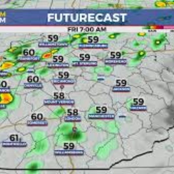
The first wave of energy is expected to move north during the early morning hours Friday, bringing scattered showers and the chance for a few rumbles of thunder. Southerly winds will remain strong at 10 to 20 mph, with higher gusts at times. These winds should keep temperatures from falling much overnight, with readings in the upper 50s by Friday morning. Showers should taper off as the morning progresses, potentially leaving much of Friday dry, breezy, and unusually mild. Afternoon highs are expected to climb into the mid to upper 60s, making it feel far from typical January weather.
A second system will move in late Friday into early Saturday, delivering another round of rain and storms. The greatest potential for heavy rain and a few stronger storms will be across Southern Kentucky, particularly near the Lake Cumberland region. While the main threat for organized severe weather is expected to stay southwest of the area, gusty showers and storms remain possible, similar to recent events over the past month. The Storm Prediction Center has placed portions of Central and Southern Kentucky under a low-end Level 1 severe weather risk for Friday night, with damaging winds as the primary concern. As the system moves northeast on Saturday, a few lingering showers are possible while winds shift to the west and cooler air begins filtering in. High temperatures should peak early in the day in the mid to upper 50s before dropping into the 40s by evening.
Winter conditions will make a more noticeable return on Sunday as colder air settles in. A weak disturbance moving through the northwest flow could bring scattered snow showers. Afternoon highs may struggle to reach the low to mid-30s, and with brisk northwest winds, wind chill values could dip into the teens at times.
Looking ahead, calmer weather is expected early next week as high pressure builds in from the southwest. Monday will start cold, with morning lows in the low 20s, but sunshine should help temperatures rebound into the upper 30s by afternoon. Milder conditions continue Tuesday, with highs reaching the mid to upper 40s under a southwest flow. Another fast-moving system may arrive Wednesday, bringing a few scattered rain showers and another push of colder air, keeping the back-and-forth temperature pattern in place.
36-Hour Forecast
Thursday Night: Breezy with scattered rain and a chance of thunder. Lows in the upper 50s. Winds south at 10–20 mph.
Friday: Morning showers followed by breezy and mild conditions. Highs in the mid to upper 60s. Winds south at 10–20 mph.
Friday Night: Another round of rain and storms. Lows in the low 50s. Winds northeast at 10–15 mph


Leave a Reply