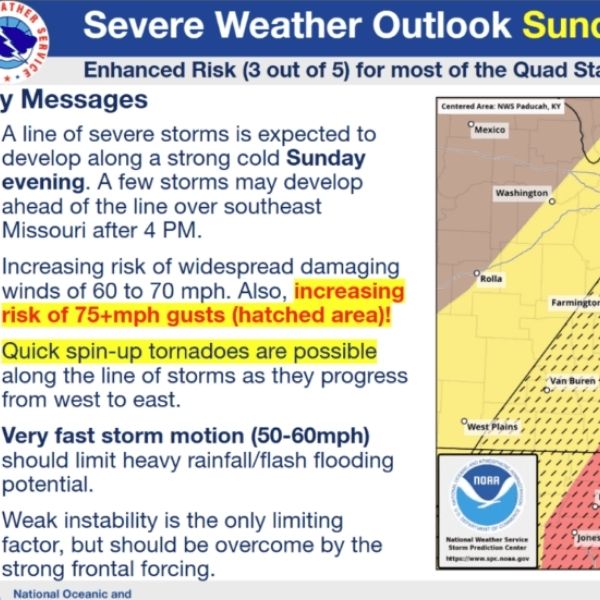
FRANKFORT, Ky. (KT) — A severe weather system is expected to move across Kentucky Sunday night into Monday, bringing high winds and the possibility of tornadoes before colder temperatures return at the start of the work week, according to the National Weather Service (NWS).
Michael Kochasic, a forecaster with the NWS office in Louisville, explained the setup. “We have a cold front coming in that’s going to bring gusty southwest winds of 40 to 50 miles per hour. Then we’re going to have a strong cold front move through. The main threat is going to be damaging straight-line wind gusts up to 70 miles per hour. That’s no joke, especially at night when many folks are going to be asleep.”
Kochasic said additional hazards are also possible. “You can’t rule out some spin-up tornadoes of up to EF-2 strength,” which can produce winds between 110 and 135 miles per hour.
He emphasized the importance of staying weather-aware, particularly since much of the severe weather could occur overnight across the state. “Please have multiple ways to receive watches and warnings: TV, radio, NOAA Weather Radio. Make sure your cell phones are charged up and that you have reliable apps that can alert you and wake you with an audible warning.”
After the front moves through, Kochasic said the rough weather will continue as strong northwest winds develop and temperatures drop sharply.
“Temperatures are going to drop. High temperatures for Monday are probably going to be early Monday morning in the 30s, then it’s all downhill from there. It’s going to get really cold as we go through Monday and Monday night, when lows are expected to drop into the mid- and upper-teens with wind chills in the single digits. Winter is just not over yet.”
He added that temperatures are expected to rebound later in the week, with forecasts showing a return to the 60s by Thursday and Friday.
Kochasic urged residents to review their severe weather plans and prepare ahead of the storm system expected to arrive Sunday.


Leave a Reply