OHIO — A developing weather pattern is raising concerns across the Ohio Valley, as a cold front is expected to move south on Sunday and could trigger thunderstorms with gusty winds and heavy rainfall.
Cold front setup brings storm potential Sunday afternoon
Forecast models show a cold front pushing southeast across the region Sunday, serving as the main trigger for thunderstorm development. While the exact timing and coverage remain uncertain, meteorologists say conditions may support organized storms during the afternoon.
The timing of the front will be critical. If it moves through during peak daytime heating, it could tap into stronger instability and increase storm intensity.
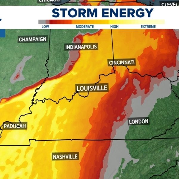
Highest instability centered over Ohio Valley
Storm energy, measured by CAPE (Convective Available Potential Energy), is expected to reach moderate to high levels across parts of Ohio, Indiana, Kentucky, and western Pennsylvania.
The greatest instability is forecast near Dayton, Columbus, Cincinnati, and extending toward Pittsburgh and nearby areas, where warm and humid air ahead of the front could help storms strengthen and organize.
Gusty winds and heavy rainfall main threats
While it is still too early to determine the exact strength of individual storms, current signals point to gusty winds and periods of heavy rain as the primary hazards.
The combination of atmospheric instability and the advancing cold front may allow storms to become more organized, increasing the risk of strong wind gusts capable of causing minor damage, along with localized downpours.
Timing and coverage still uncertain
Meteorologists stress that uncertainties remain regarding storm timing and coverage, which will play a key role in the overall impact.
An earlier arrival of the front could limit storm strength, while a later arrival would allow instability to build further, raising the chances for more widespread and stronger thunderstorms.
What this means for residents
Residents across Ohio, Indiana, Kentucky, and Pennsylvania should stay alert for updates as the situation develops. While this is not yet a confirmed severe weather outbreak, the setup warrants close monitoring heading into Sunday.
As noted in the latest forecast discussion, small changes in timing could significantly affect storm strength and coverage.
North Carolina outlook remains unaffected for now
At this time, the main storm threat remains focused on the Ohio Valley, with North Carolina not expected to be directly impacted in the short term. However, broader weather pattern shifts could influence conditions across the Southeast later in the week.


Leave a Reply