MEMPHIS, Tennessee — A powerful severe weather setup is developing for Sunday night across the Mississippi Valley, placing Illinois, Indiana, Kentucky, and Tennessee in the path of a fast-moving squall line capable of producing damaging winds and embedded tornadoes.
Recent high-resolution forecast models indicate that even with lower atmospheric instability, the strength of the wind fields and large-scale forcing could still generate a corridor of dangerous storms stretching from Arkansas and Mississippi into the lower Ohio Valley.
Low Instability but Strong Forcing
Meteorologists say this system does not resemble a traditional high-CAPE severe outbreak. Instead, it features a low-CAPE, high-shear environment.
This means:
Instability levels may remain modest in some areas
Wind shear and upper-level atmospheric dynamics are extremely strong
Storm development will depend heavily on large-scale forcing
Even a narrow or weaker-looking squall line in this type of setup can still produce powerful wind gusts and rotating storm segments capable of generating tornadoes.
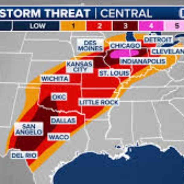
Storm Line Expected to Form in Arkansas and Mississippi
Forecast models suggest the storm line will organize across:
Western Arkansas
Northern Louisiana
Central and western Mississippi
From there, it is expected to surge northeast through:
Memphis, Tennessee
Jackson, Tennessee
Evansville, Indiana
Southern Illinois
Toward Indianapolis, Indiana
Current projections indicate the storms could reach Memphis and northern Mississippi during the evening, move toward Nashville and western Kentucky later at night, and approach southern Illinois and southern Indiana around or after midnight.
Damaging Winds Expected to Be Main Threat
The greatest risk will likely come from damaging straight-line winds, with gusts potentially exceeding 60 mph and possibly higher in stronger portions of the storm line.
Because of the powerful jet stream overhead, storms may efficiently transfer strong winds from higher levels of the atmosphere down to the surface.
Communities that could see impacts include:
Memphis, Tennessee
Nashville, Tennessee
Paducah, Kentucky
Evansville, Indiana
Vincennes, Indiana
Bloomington, Indiana
Springfield, Illinois
In similar setups, storms can produce long corridors of wind damage along the leading edge of the squall line.
Tornado Risk Remains Possible
Although damaging winds are the primary concern, forecasters warn that tornadoes could develop within the squall line, especially where instability briefly increases.
Meteorologists say:
Brief tornado spin-ups may develop within the line
Areas with slightly higher instability could see stronger tornadoes
A few stronger tornadoes cannot be ruled out
Because these tornadoes would likely form quickly and occur overnight, they may be difficult to detect and more dangerous for residents.
Overnight Timing Increases Risk
Much of the most significant severe weather could occur after dark, particularly across western Tennessee, Kentucky, southern Illinois, and southern Indiana.
This includes populated areas such as:
Memphis, Tennessee
Nashville, Tennessee
Evansville, Indiana
Communities south of Indianapolis, Indiana
Nighttime severe weather events are especially concerning because many residents may be asleep and less likely to receive warnings immediately.
Chicago Monitoring Northern Edge of System
Chicago sits near the northern edge of the strongest atmospheric dynamics. While the most intense severe weather threat currently appears south of the city, strong storms and gusty winds could still affect parts of the region as the system moves northeast.
Forecasters say residents across Illinois and Indiana should continue monitoring updates, as even small shifts in the instability pattern could move the higher-risk areas farther north.
Preparation Encouraged
With a fast-moving and potentially dangerous squall line expected, officials recommend preparing before storms arrive Sunday evening.
Suggested precautions include:
Ensuring weather alerts are turned on
Charging phones and backup batteries
Identifying a safe interior shelter location
Staying alert for weather warnings overnight
Meteorologists say the system resembles a classic early-spring severe weather event, capable of producing widespread wind damage and isolated tornadoes across several states.


Leave a Reply