Severe weather is expected to impact Kentucky tonight.
The forecast turns active this evening as a line of strong to severe storms moves across the Commonwealth. A powerful storm system bringing blizzard conditions to areas north of Kentucky will push a squall line of thunderstorms into the region late tonight and early Monday morning. Before the storms arrive, temperatures will climb into the lower to mid-70s under mostly cloudy skies. Winds ahead of the system could gust between 40 and 50 mph. Drivers should be cautious, especially on east-to-west roads, as strong southerly winds may strike vehicles broadside.
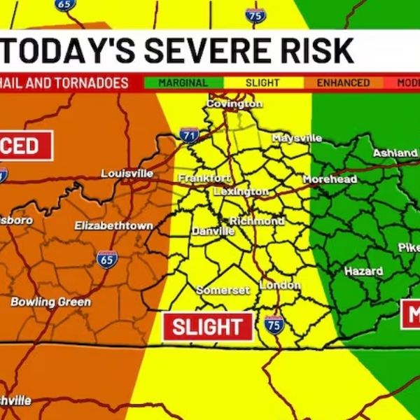
Storms will move across the state from west to east tonight. In central Kentucky, the greatest risk for severe weather is expected between 11:00 p.m. and 2:00 a.m. In eastern Kentucky, the strongest storms are likely between 2:00 a.m. and 6:00 a.m. As the thunderstorms move through, wind gusts could reach 55 to 70 mph, and isolated tornadoes cannot be ruled out, particularly in western Kentucky.
Conditions will change quickly on Monday as temperatures drop sharply. Lingering rain may transition into snow squalls, which could become heavy and intense at times. These bursts of snow may reduce visibility and leave behind a quick slushy coating on roads. The risk for slick spots will increase after sunset, especially in southeastern Kentucky where the best chance for accumulation is expected. High temperatures Monday will remain in the 30s, but it will feel much colder with wind chills in the teens.
Wind chills are expected to drop into the single digits Tuesday morning, with a few lingering snow flurries possible. High temperatures Tuesday will struggle to reach the 30s, with overnight lows falling into the teens.
A few scattered showers are possible by the middle of the week before conditions begin to improve toward the end of the week. Residents are encouraged to stay weather-aware and have multiple ways to receive severe weather alerts as the storm system moves through the region.


Leave a Reply