Another December snow event left roads slick on Sunday, though most interstates and main roads were reported in decent condition by midday. Back roads, however, remain icy, with overnight snow turning into packed, crusty ice that is likely to persist into Monday.
Snowfall totals were significant in parts of the region: eastern Ohio and north-central West Virginia (near and north of Route 33) saw 4-8 inches, while northeast West Virginia received over 10 inches. Huntington and Charleston recorded 2-3 inches overnight, contributing to slick travel conditions. Further south, snowfall ranged from a light coating to around 1 inch, with heavier amounts near U.S. Route 19. Narrow streaky bands of snow are still moving with the northwest flow, gradually tapering off this afternoon but capable of briefly reducing visibility and leaving a light dusting.
The dominant story is the cold. Temperatures dropped into the teens Sunday morning and remained there through the afternoon. Even with relatively light winds, gusts over 20 mph created wind chills in the single digits and occasionally below zero.
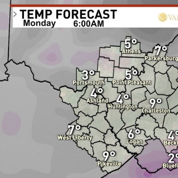
Tonight, temperatures will vary depending on cloud cover. Areas with lingering clouds—particularly along Interstate 77 East—will not cool as much, while clearer areas in northern Kentucky, eastern Ohio, and northwest West Virginia could see temperatures drop to 0 or below by Monday morning.
Monday is expected to be sunny, but highs will only reach the mid-20s, roughly 25 degrees below average.
By midweek, temperatures are forecast to become much milder. Some areas may even see gusty rain and isolated thunderstorms Thursday evening ahead of a cold front, with all snow on the ground likely gone by then.
This article has been carefully fact-checked by our editorial team to ensure accuracy and eliminate any misleading information. We are committed to maintaining the highest standards of integrity in our content.


Leave a Reply