After morning thunderstorms, gusty winds and falling temperatures shift the pattern, with a chance for snow showers by Sunday
Cooler air settles in after storms, chilly weekend ahead for central and eastern Kentucky
Showers and a few thunderstorms moved through central and eastern Kentucky early this morning, but conditions have now quieted down. Those storms developed just ahead of a cold front, which has since pushed through the region and completely shifted our weather pattern.
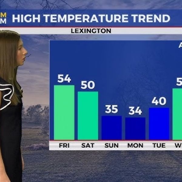
The day started off mild, with temperatures in the upper 50s and low 60s. Once the front passed, cooler air quickly followed. Afternoon highs will slide back into the low 50s under mostly sunny skies. It’s still a nice day to spend time outdoors, though you’ll definitely feel the cooler air compared to yesterday.
Gusty winds and cooler temperatures take over today
Winds picked up behind the cold front and will remain breezy for much of the day. At times, gusts could be strong enough to make it feel even cooler than the thermometer shows. Sunshine will help a bit, but you’ll want a jacket if you’re heading outside.
These cooler temperatures mark the start of a colder stretch that will settle in through the weekend and into early next week.
Clouds return tonight with a cooler feel
Cloud cover will gradually increase again tonight. By morning, temperatures will drop into the mid 30s, leading to a noticeably chilly start to Saturday.
A very small chance of an isolated shower may develop overnight in far southern Kentucky, but most areas will remain dry.
Saturday stays mostly cloudy but milder than Sunday
Saturday brings mostly cloudy skies, with afternoon highs reaching the upper 40s to low 50s. While it won’t feel as cold as Sunday, temperatures will still run cooler than earlier this week.
Rain chances stay very low, and most locations should remain dry throughout the day.
Colder air returns Sunday with a chance for snow showers
Colder air settles in again on Sunday, with high temperatures struggling to move beyond the mid 30s. It will feel much more like winter once again.
A few snow showers could develop, especially during the afternoon. At this point, no accumulation is expected. Some spots may briefly see flakes in the air, but this appears to be more of a wintry reminder than a significant snow event.
Cold start to next week before warmer weather returns
Monday remains mostly cloudy, with highs once again in the mid 30s. Overnight temperatures early next week could dip into the teens, creating a cold start to the mornings.
By the middle of next week, temperatures will begin to climb again. Highs will return to the low 50s, and another system may bring rain chances by Thursday.
36-Hour Forecast
Friday Night: Conditions turn cooler with increasing clouds. Lows fall into the mid 30s, with a slight chance of an isolated shower in southern Kentucky.
Saturday: Mostly cloudy and cool. Highs reach the upper 40s to low 50s. Most areas stay dry.
Saturday Night: Colder air moves in as temperatures drop into the low to mid 30s. Clouds linger, setting up a chilly feel for Sunday.
This article has been carefully fact-checked by our editorial team to ensure accuracy and eliminate any misleading information. We are committed to maintaining the highest standards of integrity in our content.


Leave a Reply