Max Velocity says this winter pattern is about to take a sharp turn—and it won’t wait politely until after the holidays.
In his latest forecast, he describes a holiday week that began as a West Coast problem but is now evolving into a nationwide headache.
He warns this isn’t just about a warm Christmas anymore. In Max Velocity’s view, it’s turning into a “more chaotic” setup, with high-impact storms stacking on one another while records fall in the background.
A Warm Christmas Turns Into a Bigger, Stranger Pattern
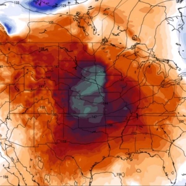
Max Velocity explains that a major heat dome is building and spreading across much of the United States. Outside the Rockies and a few colder pockets in the Upper Midwest, Northern Plains, and parts of the Northeast, there’s hardly any snow on the ground.
Earlier, he forecasted the warmest Christmas on record for nearly 100 million Americans. Now, he warns that nearly half the country could see record-shattering warmth that might linger close to New Year’s.
He says temperatures could run up to 40 degrees above average in some areas—a level of warmth that feels more like the season is broken than mild.
Max Velocity also highlights unusually warm overnight temperatures. Christmas morning lows could break dozens of “warmest Christmas morning” records. While warm nights may sound pleasant for those tired of scraping ice off windshields, they can create fog, meltwater, and slippery roads—especially in areas that had snow just days before.
West Coast Storm Becomes a Flood and Debris Threat
The biggest update in Max Velocity’s forecast is how the West Coast storm is intensifying. What started as a localized system is now a widespread, high-impact event.
He warns of a high risk for catastrophic flash flooding near the Palisades burn scar outside Los Angeles. Multiple inches of rain in a short time could trigger fast runoff and debris flows. Burn-scarred ground can’t absorb water normally, turning rain into mud, rocks, and debris racing downhill.
California could see extreme rainfall in some areas, delivered in a short, intense burst rather than a slow drizzle. The Pacific Northwest may also face heavy rain, mountain snow, and strong winds, with gusts potentially reaching 50–60 mph—enough to knock out holiday lights and power lines.
Storm Shifts Toward the Midwest and Northeast
Parts of the West Coast system could break off, intensify, and become a major winter storm for the Midwest, Great Lakes, and Northeast. This makes the overall forecast feel like it’s accelerating.
Max Velocity says widespread accumulating snow is “likely” somewhere in that corridor. He warns that strong winds behind a cold front could create blizzard conditions for millions during the holiday travel rush. Even modest snowfall can become dangerous when high winds reduce visibility and drift snow onto cleared lanes.
He also mentions Alberta Clipper-like systems and fast-moving moisture bands between pressure systems, which are hard to predict until the last minute—another reason he emphasizes staying updated.
Snow and Ice: Where It Matters Most
Snow in New England isn’t expected to be extreme, but several inches could accumulate in spots, with southern Maine seeing higher totals. Ice is a bigger concern, especially in parts of Wisconsin and Michigan, including around Kalamazoo, where freezing rain could reach a tenth to a fourth of an inch.
For the Northeast, snow and mixed precipitation Friday into Saturday could disrupt travel. Areas like New Jersey, eastern Pennsylvania, Long Island, and southern New York could see 3–6 inches of snow, with isolated higher amounts. Ice could also impact roads and cause minor outages in Pennsylvania, Maryland, and Washington, D.C.
After Christmas: Warmth Then Possible Arctic Flip
The warmth won’t disappear immediately after Christmas. Max Velocity expects it to persist for a few days across the Plains, Midwest, and Ohio Valley.
By the end of the month, an arctic blast could push into the Northern Plains, Midwest, and eventually the East Coast. If it flips strongly enough, below-freezing temperatures could reach as far south as Jacksonville and Tallahassee, creating classic “weather whiplash”—from opening windows to frozen pipes within a week.
Max Velocity emphasizes that details become more uncertain the further out the forecast goes, but the overall message remains clear: the pattern is reorganizing fast, records are at risk, and storm threats now span multiple regions.


Leave a Reply