A potentially active pattern is setting up from the Midwest through the Deep South, with Wednesday, Thursday and Friday each showing signals for organized thunderstorms. While details will evolve, forecast guidance suggests Friday may carry the strongest overall severe signal.
Wednesday: Ohio Valley in Focus
Initial parameters highlight portions of:
-
Kentucky
-
Indiana
-
Southern Ohio
-
Western West Virginia
Cities including Louisville, Lexington, Cincinnati and Indianapolis sit within the zone where wind shear and instability may briefly overlap.
At this stage, instability appears somewhat limited. However, strong wind shear profiles could support isolated strong to severe storms if adequate moisture returns northward.
Thursday: Risk Shifts South and West
By Thursday, the corridor of concern expands into:
-
Western Kentucky
-
Tennessee
-
Arkansas
-
Northern Mississippi
Forecast guidance indicates a stronger overlap of instability and shear compared to Wednesday. If Gulf moisture advances sufficiently, organized thunderstorms could develop, with damaging winds and isolated tornadoes possible.
Moisture depth and storm timing will be critical factors in determining overall severity.
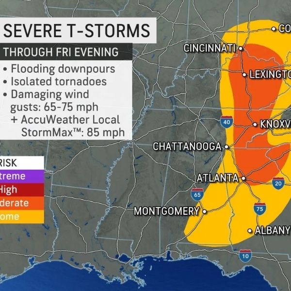
Friday: Stronger Signal Across the Deep South
The most pronounced signal currently appears Friday, with favorable storm ingredients expanding across:
-
Louisiana
-
Mississippi
-
Alabama
-
Portions of the Florida Panhandle
Wind shear remains strong, and richer instability may develop farther south where deeper Gulf moisture resides. If current trends hold, Friday could present the most organized severe threat of the week, with all hazards — damaging winds, large hail and tornadoes — possible.
Why the Multi-Day Pattern Matters
Multi-day severe setups increase forecasting complexity. While each day has slightly different ingredients and geographic focus, the broader pattern suggests:
-
Persistent upper-level support
-
Repeated Gulf moisture transport
-
Strong wind shear across the Midwest and South
The key uncertainty is how much instability ultimately develops. If moisture underperforms, storms may remain isolated. If it overperforms, more robust and widespread severe weather could materialize.
Residents from the Ohio Valley through the Lower Mississippi Valley should monitor updated forecasts throughout the week, as subtle shifts could change local risk levels.


Leave a Reply