As the most intense cold begins to ease across the Northeast this week, AccuWeather forecasters caution that the stormy winter pattern is not finished yet.
Across the eastern United States, this winter has felt relentless in recent weeks, with repeated disruptive storms and persistent, dangerous cold impacting much of the region.
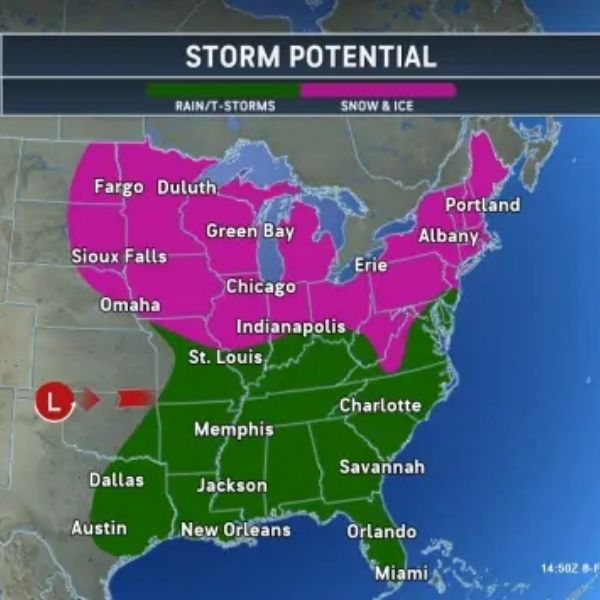
The week will begin mostly dry across the Northeast and Southeast as high pressure settles in. By midweek, a clipper-type system is expected to affect areas from the Great Lakes to New England as temperatures trend slightly warmer in some locations. Attention then shifts to a potential larger storm that could develop across much of the East next weekend.
AccuWeather long-range meteorologists have been tracking the possibility of another winter storm forming during the second week of February, including Valentine’s Day weekend. While several factors will determine the storm’s strength and path, the setup remains worth watching.
Early to midweek clipper
Forecasters are monitoring a developing system that could bring a mix of wintry weather to parts of the Great Lakes and Northeast by midweek.
“There is the possibility for a northern-tracking storm that can bring snow to the Great Lakes and Northeast Monday night into Wednesday. This storm will be on a surge of less harsh conditions as Arctic air retreats north. This can lead to a narrow zone of ice from Michigan to New York,” said AccuWeather Senior Meteorologist Adam Douty.
Most areas along the colder, northern edge of the system could see 1 to 3 inches of snow through midweek. Higher elevations, including Ski Country in western New York and the Adirondacks through the Green and White Mountains of New England, could see totals up to the AccuWeather Local StormMax of 6 inches.
Travelers are urged to stay alert as snow spreads across the region, especially along portions of interstates 81, 87, 91, and 93 in parts of New England.
As the system moves through the Northeast, it will help draw warmer air northward, offering a welcome break after the bitter cold over the weekend.
From Tuesday into Wednesday, many locations are expected to see highs climb into the 40s. Those temperatures may feel especially mild after AccuWeather RealFeel values dropped to 30 to 40 degrees below zero in windy conditions on Saturday.
In the days ahead, the harshest Arctic air will continue retreating north, easing pressure on the energy grid and offering relief to residents. Prolonged cold earlier this winter increased heating demand and contributed to higher-than-average electricity bills for many households.
Valentine’s Day storm potential
Heading into the weekend, another storm could develop across the eastern United States, bringing a range of possible weather impacts depending on its track.
“Another storm later in the week can be more southerly tracking and has the potential to bring snow, or a rain and snow mix, to the southern Appalachians and potentially into Virginia and North Carolina,” Douty said.
Several scenarios remain possible, including a more southern track that could raise flooding and severe thunderstorm risks along the Gulf Coast and Southeast, or a more northern path that would bring additional snow and ice to the Midwest and Northeast.
Even with uncertainty in the storm’s track, rain and thunderstorms developing across the South could heighten flooding concerns as deep Gulf moisture feeds into the system. While rainfall would help ongoing drought conditions from Texas to the Carolinas, including areas of extreme drought, dry ground could increase the risk of rapid runoff.
As the system develops in the coming days, forecast details will become clearer. AccuWeather will continue to provide updates on the potential Valentine’s Day storm and its impacts.


Leave a Reply