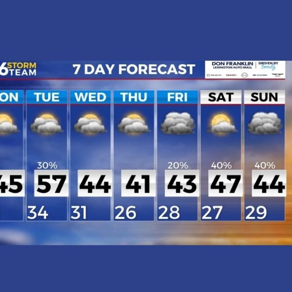
Sunshine returns Monday with temperatures rising into the 50s before rain chances develop Tuesday evening
Cold hangs on tonight before a big warm-up arrives across Kentucky
Today remained chilly across central and eastern Kentucky, but change is finally on the horizon. Clouds limited warming this afternoon, leaving most communities stuck in the mid to upper 20s, while a few southern areas reached the 30s. Despite the cold, conditions are lining up for a noticeable warm-up as the new week begins.
Clouds stick around tonight with another cold night ahead
Cloud cover will persist across much of the area tonight, helping prevent temperatures from dropping as sharply as in recent nights. Still, it will be cold, with lows falling into the low 20s for most locations. Some northern communities may dip into the upper teens before temperatures level off overnight.
Monday brings sunshine and a much-needed temperature rebound
Monday marks the shift toward more typical late-winter conditions instead of the deep freeze that has lingered. An upper-level ridge moves overhead, allowing sunshine to return and warmer air to move in.
Highs will rise into the upper 40s and even the low 50s across parts of central and southern Kentucky. After several days of below-freezing afternoons, this will feel like a significant improvement.
There is also a chance for patchy fog late Monday night as warmer, slightly more humid air moves over melting snow and damp ground. Not everyone will experience it, but it is something to monitor heading into Tuesday morning.
Tuesday turns even warmer with a few showers possible in the south
The warming trend continues Tuesday, with many communities reaching the mid to upper 50s. A few southern locations could approach 60 degrees.
A weak cold front will arrive late Tuesday. While most areas stay dry, a few light rain showers may develop Tuesday evening, mainly across southern Kentucky. Rainfall amounts appear minimal, and many northern locations may see no rain at all.
Any showers that form should clear out by early Wednesday morning.
Cooler but dry midweek before active weather returns
Behind Tuesday’s front, temperatures will cool slightly but remain seasonable. Highs on Wednesday and Thursday will settle into the 40s and low 50s under mostly dry conditions.
Looking ahead to late week and next weekend, the pattern becomes more active again. Several systems could bring additional rain chances and possibly some wintry precipitation, depending on temperature trends. Forecast confidence decreases later in the week, but the ABC 36 Storm Team will continue to monitor the situation closely.
36-Hour Forecast
Sunday Night: Mostly cloudy and cold. Low temperatures in the low 20s.
Monday: Partly sunny and much warmer. Highs in the upper 40s to near 50 degrees.
Monday Night: Partly cloudy with a chance of patchy fog developing late. Lows in the low to mid 30s.


Leave a Reply