After a relatively calm start to 2026 for much of the country, a renewed storm threat is expected to move in by the end of the week, bringing a mix of colder temperatures, heavy rain, and even snow to parts of the U.S.
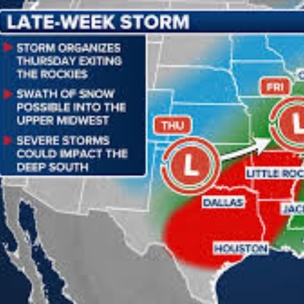
According to the FOX Forecast Center, the storm system is set to develop on Thursday and linger through Saturday. The setup begins in the Southwest, where a cut-off low currently stalled over the Pacific is forecast to move inland and hover over the Rockies.
A cut-off low is an upper-level weather system that becomes detached from the main jet stream, allowing it to stall until it is pushed forward or reabsorbed. Once this system begins moving again, it could help organize a strong surface storm, especially if colder northern air interacts with warmer southern air. Meteorologists say this interaction is likely to occur, though the exact strength and impacts of the system remain uncertain.
Meanwhile, parts of California are already dealing with dangerous weather. Torrential rain has inundated sections of the state, triggering flash flood threats and forcing the closure of two major highways. Additional rain is expected, along with snow at higher elevations, as back-to-back storms continue to impact the region. Southern California started the new year with widespread rainfall, and reports of street flooding emerged in several areas, including Palm Springs.
If the developing system shifts into the Southern Plains on Thursday, it could spark a severe weather outbreak into Friday. Areas farther south, including the Southern Plains and Deep South, may see a cold front sweep eastward from the main low-pressure system. Depending on available energy and instability, a few severe storms could develop, capable of producing damaging winds, hail, and possibly a brief tornado.
Cities such as Louisville, Kentucky, and Cincinnati, Ohio, could receive more than two inches of rain on Friday. A level-one flash flood threat is already in place for parts of the central United States.
At the same time, a wide range of winter weather is possible elsewhere. From the Rockies to the Upper Midwest, there is potential for heavy snowfall across portions of Colorado, New Mexico, and into Minnesota.
As the system progresses, impacts are expected to shift into the Great Lakes and Northeast from Saturday into Sunday. Gusty winds and blowing snow could affect parts of the Great Lakes, while a cold front moving through the South may lift northward into the Northeast, bringing showers and thunderstorms.
States including Connecticut, New York, New Jersey, and Maine can expect periods of heavy rain through the weekend. At this time, forecasters do not anticipate major severe weather or flooding concerns in the Northeast.
Conditions across the country are expected to improve by late Sunday, with most areas drying out as the new week begins.
This article has been carefully fact-checked by our editorial team to ensure accuracy and eliminate any misleading information. We are committed to maintaining the highest standards of integrity in our content.


Leave a Reply