UPDATE – 7:35 P.M. Tuesday 12/2/25: The latest GFS model for Sunday now looks similar to the European model, showing little to no snow. This major change is why the forecast remains at a 30% chance for that period.
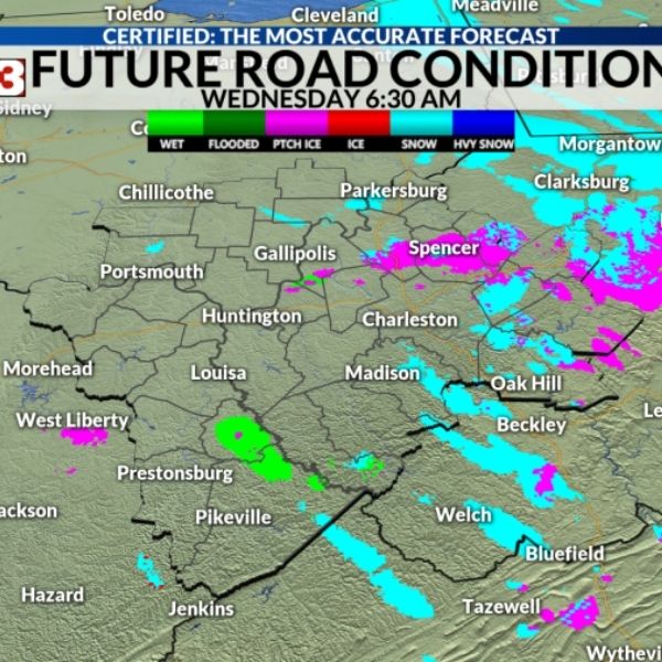
After Tuesday morning’s snowfall, many are watching the skies to see when the next round of snow might arrive. However, wet and damp areas late Tuesday could refreeze, creating black ice early Wednesday.
Road models for Wednesday morning show icy or snowy spots, especially east of U.S. 119 in southern West Virginia and east of I-79 in central West Virginia.
The next chance for snowflakes appears Thursday morning ahead of a cold front, but this isn’t expected to be a significant event.
Another fast-moving system will arrive from the south, bringing a mix of precipitation late Friday in southern West Virginia and southeast Kentucky. The European model shows this precipitation reaching north of I-64, so forecasters will continue monitoring for changes.
A new weather system could affect the region late Sunday and early Monday. The American GFS model shows a strong rain-to-snow transition, but the European model does not. StormTracker 13 meteorologists say it’s best to highlight the higher-end possibilities for now and refine the forecast as it gets closer. Preparing for slick roads is better than being caught off guard if the GFS model is correct. At five days out, this remains a possibility.
Since the system is not yet certain, it’s too early to know whether any accumulation will occur. Still, the next potential winter impact could come late Sunday night and early Monday morning.
The weather pattern stays active next week with more clipper systems moving in from the north around midweek, bringing another chance for a wintry mix.
So far, December looks quite cold, and while snowfall may stay light, the timing could still create travel impacts.


Leave a Reply