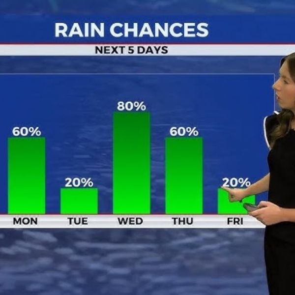
Keep those jackets and umbrellas close — rain chances will stick around through midweek.
Clouds Linger with Light Showers to Start the Week
After a mostly cloudy Sunday, central Kentucky saw a few fleeting moments of sunshine before clouds returned. Afternoon highs reached the low to mid-60s, cooler than usual for late October. A few light showers passed through, and rain chances will rise tonight as more moisture moves in from the south.
More Clouds and Showers Move In
Clouds will continue thickening this evening as a slow-moving low-pressure system over the southern Plains drifts east, spreading light rain from southwest to northeast. Southern Kentucky will likely see the steadiest rainfall, while northern areas may get lighter showers.
Overnight lows will stay mild due to the cloud cover, dropping into the upper 40s, while parts of southern Kentucky may only fall into the low 50s.
Damp and Cool Start to the Week
Monday will stay gray and cool with periods of light rain. Though it won’t be a complete washout, you’ll still need that rain jacket. Highs will struggle to reach the mid-50s to near 60, which is well below average for this time of year.
Winds from the east-northeast at 5 to 10 mph will add to the chilly, damp feel.
Showers Taper Off, Clouds Stick Around
As the system shifts east, rain chances will gradually fade Monday night. A few scattered showers may linger, mainly east of I-65, but most areas will dry out overnight. Temperatures will fall into the upper 40s and low 50s with low clouds hanging around into early Tuesday morning.
Midweek: More Rain on the Way
After a short break Tuesday, another system will move in from the northwest, bringing widespread rain Tuesday night into Wednesday. This round could be heavier, with 1 to 2 inches of rainfall possible — and some areas could see even more depending on where the strongest bands develop.
Temperatures will remain cool all week, with highs in the mid-50s to near 60 and lows in the 40s — around 10 degrees below average for late October.
By Thursday, most of the rain should move out, though a few isolated showers might linger into Thursday or Friday.
Looking Ahead
The week stays active with cool, damp weather and occasional light rain. However, by the weekend, high pressure should return, bringing sunshine and drier conditions — a welcome change as we head into early November.
ABC 36 Storm Team 36-Hour Forecast
-
Sunday Night: Cloudy with increasing showers, especially in the south. Low in the upper 40s.
-
Monday: Cool and breezy with periods of light rain. Highs in the upper 50s.
-
Monday Night: Scattered showers taper off, mostly cloudy. Lows in the upper 40s.
This article has been carefully fact-checked by our editorial team to ensure accuracy and eliminate any misleading information. We are committed to maintaining the highest standards of integrity in our content.


Leave a Reply