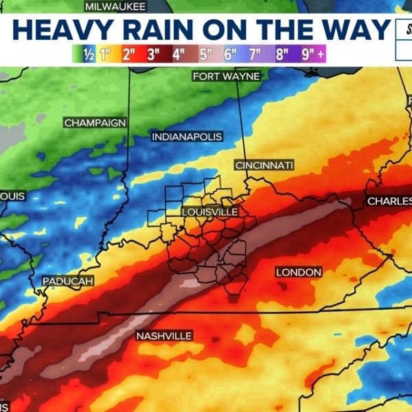
After several dry days, Louisville could see thunderstorms and heavy rainfall this weekend, according to the National Weather Service (NWS) in Louisville.
Meteorologist Evan Webb said a strong cold front is expected to move through the region late this week, bringing the greatest chance for storms from the afternoon into the night of Oct. 18.
“It’s really just a matter of how strong the thunderstorms will get,” Webb explained.
Forecasters predict 1 to 2 inches of rain, which could raise flooding concerns in some areas. However, Webb noted that it’s still too early to determine exact rainfall totals, as current models remain uncertain.
“The timing is tricky at this range,” he added.
Louisville Weather Forecast
Oct. 15
Sunny with a high near 74°F. Calm winds shifting northeast around 5 mph in the afternoon. Mostly clear at night with a low near 53°F and light east wind.
Oct. 16
Sunny with a high around 71°F and light east winds near 6 mph. Mostly clear at night with a low near 49°F.
Oct. 17
Partly sunny with a high near 75°F. Partly cloudy at night with a low around 60°F.
Oct. 18
A 40% chance of showers and thunderstorms after 2 p.m. Mostly sunny with a high near 78°F.
At night, showers and thunderstorms are likely—especially between 8 p.m. and 2 a.m.—with a 70% chance of precipitation and a low around 56°F.
Oct. 19
A 40% chance of showers, with mostly sunny skies and a high near 67°F. At night, expect a 20% chance of rain and a low around 45°F.
Oct. 20
Sunny and pleasant, with a high near 66°F.


Leave a Reply