Sunshine kicks off the week, but a soaking rain arrives by Tuesday.
A Quiet, Breezy Sunday with Plenty of Sunshine
Sunday delivered another beautiful but cool fall day across the region. Afternoon highs reached the mid to upper 50s, with some southern spots touching the low 60s. Sunshine dominated, but breezy northwest winds added a touch of chill. Behind last night’s cold front, much drier air settled in.
Temperatures will drop sharply tonight under clear skies and lighter winds. Overnight lows will fall into the low 30s, with some rural areas dipping into the upper 20s by early Monday.
Monday: Sunshine Sticks Around Before Rain Moves In
If you enjoyed Sunday, Monday will be just as pleasant. High pressure remains in control, keeping skies sunny with light winds and seasonable temperatures. Highs will reach the mid 50s.
Dry air holds through most of Monday, but changes come Monday night. A developing system over the Plains will move toward the Ohio Valley, bringing increasing clouds and eventually rain.
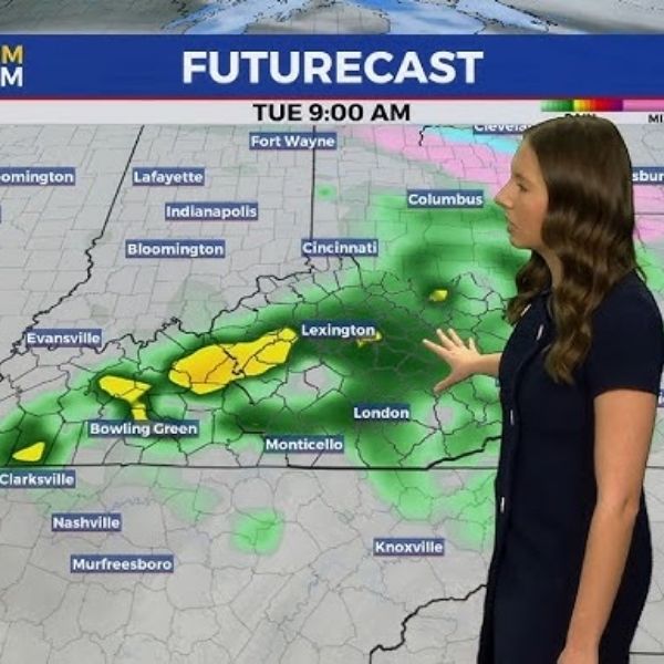
Rain Returns Tuesday, Beginning a Wet Stretch
Rain chances climb late Monday night and into Tuesday morning as the first wave of moisture arrives. Expect scattered to widespread rain throughout Tuesday, with the possibility of a few rumbles of thunder due to elevated instability. Rain continues into Tuesday night as a warm front sets up in Kentucky, creating a large temperature spread across the region. Highs will range from the mid to upper 50s in the Bluegrass to the upper 60s and near 70 degrees in far southwestern counties.
More Rain Through Mid to Late Week
Rain lingers into Wednesday, though amounts should be lighter and more isolated than Tuesday.
But the wet pattern won’t end there. A stalled boundary and multiple waves of moisture will keep rain chances going through the end of the week. Some models show 1 to 3 inches of total rainfall from Tuesday through Saturday, though details are still developing.
Temperatures warm again by midweek, with highs returning to the mid and upper 60s for the latter half of the week.
ABC 36 Storm Team 36-Hour Forecast
Sunday Night: Clear and cold with lows in the upper 20s to low 30s. Light winds.
Monday: Mostly sunny, cool, and dry. Highs in the mid 50s.
Monday Night: Increasing clouds with showers developing after midnight. Lows in the mid to upper 40s.
This article has been carefully fact-checked by our editorial team to ensure accuracy and eliminate any misleading information. We are committed to maintaining the highest standards of integrity in our content.


Leave a Reply