Meteorologist Max Schuster says the country is entering a stretch of weather that feels less like a normal seasonal shift and more like the atmosphere is throwing everything together at once.
In his latest forecast on Max Velocity – Severe Weather Center, Schuster called it “March Madness,” and the description fits. A record-breaking heat dome is spreading across large parts of the country, with hundreds of temperature records expected to fall. He also warns that once this unusual warm pattern weakens next week, conditions could quickly shift toward snow, stronger storms, and a very different setup by early April.
That is what makes this forecast stand out. It is not just about rising temperatures. This heat is arriving in a highly unusual way for March, and according to Schuster, its breakdown could set the stage for another round of active weather soon after.
For those who have watched this month swing from severe storms to late cold snaps and now into near-summer warmth, the message is clear: March is not finished delivering surprises.
Max Schuster Says This Is Not A Normal Spring Warm-Up
Schuster makes it clear that this pattern is far more intense than a typical late-March warm spell.
He says more than 300 daily temperature records could be broken in just a few days, something he describes as extremely rare for March. That is why he stresses this is not an ordinary warm-up. In his view, this could rank among the most intense March heat waves in years, with the potential to challenge even all-time monthly records in parts of the West.
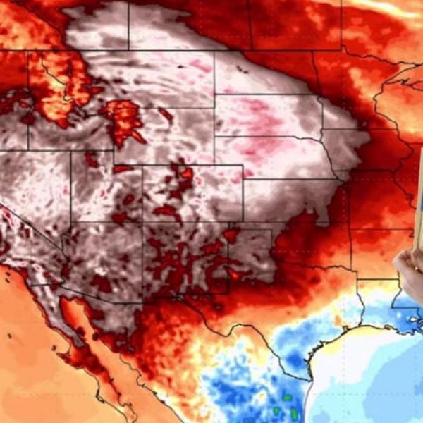
He explains that the jet stream is driving this pattern. A strong ridge has built over the Desert Southwest, acting like a massive heat dome that pushes warm air north and east across much of the country. At the same time, the jet stream dips from the northwest into the Midwest and Northeast, allowing cooler air to linger along the East Coast even as much of the map starts to resemble late May.
This contrast adds to the unusual nature of the setup. Some regions remain in a late-winter pattern, while others move toward temperatures that are far too warm for this time of year.
Schuster says plainly that “everyone is going to feel it.” Even if conditions vary by region, the overall pattern is dramatic enough that few places remain unaffected.
The Heat Dome Is About To Spread Well Beyond The Southwest
One of the most striking parts of Schuster’s forecast is how far the warmth will extend.
He says that by the weekend, the heat will not stay limited to southern California and Arizona. Instead, it will expand across the Great Plains, surge through the southern Plains, and push temperatures into the 80s and 90s in areas that are typically much cooler in late March.
This includes parts of Texas, Oklahoma, Kansas, and Missouri. He adds that even regions as far north as Minnesota and the northern Plains could approach 80 degrees. In the southern areas, some locations may see temperatures more typical of late May or early June.
That kind of shift stands out because it clearly exceeds seasonal expectations. When Midwestern cities begin seeing temperatures typical of two months later, it feels less like spring and more like an overshoot.
Schuster also highlights the Southwest, where conditions may become even more extreme. He says some parts of California could near 110 degrees and notes that areas near Mecca, California, are already approaching the highest March temperatures ever recorded in the United States. Even where records are not broken, daily highs could exceed previous marks by 10 to 15 degrees.
Nighttime temperatures also tell the story. He points out that overnight lows in parts of California and Arizona could stay in the 70s and low 80s, another sign that this is far from a typical spring pattern.
The Record-Setting Heat Will Not Last Forever, But The Cooldown Could Be Abrupt
Despite the intensity, Schuster emphasizes that this heat will not last.
He says the heat dome will begin weakening by Sunday as the jet stream flattens and the ridge loses strength. Once that happens, a cold front is expected to move through the Midwest and Northeast, dropping temperatures by 20 to 40 degrees in some areas.
Such a sharp shift can catch people off guard. After several days of unusual warmth, it is easy to assume the season has fully changed. However, Schuster warns that this pattern will not end that way. Instead, some regions could quickly transition from near-summer conditions back to a late-winter feel.
He adds that the Northeast is likely to remain in a more winter-like pattern compared to the rest of the country, explaining the recent inconsistency across the national map.
The more intriguing aspect is what follows the cooldown.
Schuster says the pattern will turn more “funky” early next week as the jet stream becomes flatter, typically limiting large storm systems. Still, he does not expect a completely quiet period.
Instead, he sees signs that the breakdown of the heat dome could open the door for snow and some severe-weather potential later in the week, especially if a storm system tracks slightly farther south.
A Weird In-Between Week Could Bring Snow, Storms, And Fire Risk
Schuster avoids overstating uncertain details.
He says the chances of a major severe-weather event by mid-to-late next week remain relatively low, around 10%, but still worth watching. He expects at least some isolated to scattered storms if conditions develop favorably.
This means people should not expect a major outbreak immediately, but they also should not assume the pattern will quiet down once the heat fades.
He specifically mentions that Ohio, West Virginia, and Pennsylvania could see a low-end severe weather threat later in the weekend. However, limited moisture and instability may keep impacts relatively minor, with isolated hail or wind more likely than widespread damage.
Looking ahead, Schuster identifies a stronger system expected to move through Canada late next week. If it shifts farther south, it could bring more significant thunderstorms to parts of the Midwest, Ohio Valley, and mid-Mississippi River Valley. Otherwise, it may primarily result in a strong snowstorm in Canada.
Snow remains part of the forecast. Schuster says some areas in the Midwest and Northeast could still see snowfall by the end of the month. This means that while some regions experience near-record heat, others may still deal with late-season winter conditions.
He also highlights fire weather as another concern. By midweek, parts of Texas, Oklahoma, and Kansas could face hot, dry, and windy conditions that increase fire risk.
This shows that the heat is not just unusual. It also raises the potential for additional hazards.
The Pacific Northwest Could Turn Wet And Wintry While The Rest Of The Country Shifts Again
Schuster says the Pacific Northwest may also see active weather next week, with heavy rain and mountain snow.
This adds another contrast within the overall pattern. While heat builds across central and southern regions, the Northwest could experience colder and wetter conditions, creating a highly varied national weather picture.
He does not describe this as a major national event, but it reinforces the idea that the country is not moving into a uniform spring pattern. Different regions are experiencing entirely different conditions at the same time.
That is why Schuster’s description of the setup as “March Madness” fits so well. It accurately reflects the chaotic nature of the pattern.
Max Schuster Expects Early April To Bring More Active Weather
As he outlines the next 7 to 10 days, Schuster also looks ahead to early April and sees increasing activity.
He expects the severe-weather pattern to become more active again, with multiple outbreaks possible. The first significant round could occur between April 2 and April 5.
This does not guarantee immediate severe weather, but it suggests the current heat dome is part of a larger transition rather than an isolated event. It may represent the atmosphere shifting into a more active spring pattern.
That perspective matters because it prevents people from assuming the upcoming warmth signals stability. Instead, Schuster views it as a brief and unusual phase before the next active period begins.
If his forecast holds, the takeaway is not that conditions are calming down. It is that they are reorganizing.
This Is One Of Those Forecasts That Stands Out
Some weather patterns fade quickly from memory, but others stand out immediately.
Schuster is forecasting one of those memorable stretches. A powerful March heat dome will push temperatures far beyond typical levels. Hundreds of records may fall. The Plains and Upper Midwest could feel like late spring. The Southwest may challenge all-time March records. Then, temperatures may drop sharply, snow could return in some areas, and the setup may lead to more active weather into early April.
It is a complex forecast, but that is exactly why Schuster calls it “March Madness.”
This is not a single, simple weather story. It is a sequence of extremes, from heat to cold, with potential storms, snow, and fire risk, all unfolding across different regions at the same time.
For those trying to plan ahead, the simplest takeaway is clear: enjoy the warmth while it lasts, but do not expect stability. If Schuster’s outlook proves accurate, this heat dome is just one part of a much more unpredictable stretch of weather still to come.


Leave a Reply