SHORT TERM: Near-record highs in the 70s on Tuesday, Alert Day for Wednesday with strong to severe storms
LONG TERM: Cooler and quieter Thursday, windy Friday, warmer Saturday
FORECAST
WAVE Overnight Weather – Monday, March 9, 2026
LOUISVILLE, Ky. (WAVE) – Cloudy skies and warm conditions will continue overnight as a warm front moves through the area. This will also trigger scattered showers and thunder beginning after 3 a.m. Tuesday morning.
Severe weather is not expected overnight, but the thunder may wake some people. Once the scattered morning showers move out by midday, skies will remain mostly cloudy with a slight chance of an isolated shower. Afternoon temperatures Tuesday will climb into the mid to upper 70s.
The record high for Louisville is 78° set in 2009. Conditions should remain mostly dry and calm Tuesday night before storms reach southern Indiana counties just before sunrise Wednesday. Overnight lows will stay in the warm 60s, so many homes may not need heating.
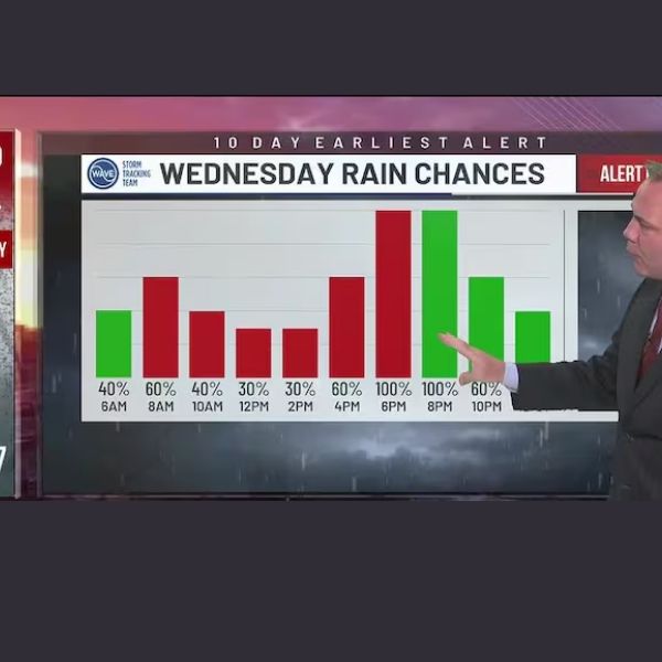
Wednesday has been designated a WAVE Weather Alert Day as strong to severe storms are possible between 8 a.m. and 8 p.m. ET. An initial round of storms may develop early in southern Indiana, followed by a stronger line of storms affecting the entire region by evening.
Wind, hail, and isolated tornadoes are possible.
A sharp temperature drop is expected behind the cold front Wednesday night, with temperatures falling into the 30s by Thursday morning.
After a quiet and cooler Thursday with highs in the 40s for many areas, Friday will turn windy as a strong system moves through the Great Lakes. Despite the gusty conditions, the region should remain dry heading into the weekend.
Another active weather pattern may begin Sunday with storms and wind, followed by a sharp drop in temperatures by Monday morning. Snow showers and slick spots are possible, and Sunday afternoon through Monday morning has been flagged as Alert Days.


Leave a Reply