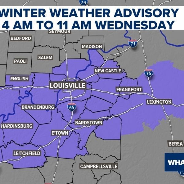
A winter weather advisory remains in effect for portions of Kentucky and Southern Indiana until 10 a.m. March 2, according to the National Weather Service Louisville.
Forecasters warn of a “wintry mix” of snow, sleet and freezing rain, mainly north of the Interstate 64 corridor. In areas where temperatures fall below freezing, bridges and overpasses could become slick, creating minor travel impacts.
Because of the advisory, Oldham County Schools and Shelby County Public Schools announced closures for the day, citing safety concerns.
NWS officials said precipitation types remain uncertain for areas along and south of I-64, including the Louisville metro. A minor slushy accumulation is possible, and there is a 50% to 70% chance Louisville could see a light glaze of ice.
As temperatures climb above freezing by mid-morning and afternoon, road conditions are expected to improve.
Wet pattern, severe storm chances ahead
Looking ahead, forecasters expect an “increasingly wet” pattern next week. Louisville could see above-average precipitation between March 9 and 15. The NWS says multiple rounds of strong or severe thunderstorms are possible, urging residents to monitor forecasts and prepare for potential flooding or severe weather.
Louisville Weather Forecast
March 2
Rain is expected before 4 p.m., with a high near 39 degrees. Up to a quarter-inch of new precipitation is possible, with a 90% chance of rain. Overnight will be cloudy, with a low around 38 degrees and a 40% chance of rain before 10 p.m.
March 3
High near 66 degrees, with up to a quarter-inch of precipitation possible and an 80% chance of rain. Nighttime will be mostly cloudy, with a low around 56 degrees and a 40% chance of showers.
March 4
Cloudy skies with a high near 74 degrees and a 60% chance of precipitation. Showers are likely, and thunderstorms are possible after 4 p.m., potentially bringing more than a quarter-inch of rain. Overnight will remain mostly cloudy, with a low around 61 degrees and a continued chance of showers and storms.
March 5
High near 72 degrees with showers likely and an 80% chance of precipitation. Overnight will be mostly cloudy, with a low of 58 degrees and showers likely after 1 a.m.
March 6
Partly sunny with a high near 78 degrees and a 50% chance of showers and thunderstorms. Overnight will be partly cloudy, with a low around 63 degrees and a 40% chance of showers and storms after 1 a.m.
March 7
Mostly showers with a high near 74 degrees and a 90% chance of precipitation. Nighttime will be mostly cloudy, with a low around 54 degrees and a 40% chance of showers.
March 8
Mostly cloudy with a high near 67 degrees and a 50% chance of showers.


Leave a Reply