Another wave of snow could hit parts of the South and East this weekend as a storm develops, threatening areas recently impacted by ice and heavy snow.
The final week of January may bring disruptive wintry weather following a massive storm that left ice across the South, more than a foot of snow in the North, and over 1 million people without power.
Cold temperatures will dominate much of the eastern half of the country. The Ohio Valley, Northeast, and Midwest are expected to stay below freezing all week, while even Texas, the Mississippi River Valley, and the Southeast could see below-freezing nighttime temperatures.
The settled cold across the South and East sets the stage for another potential winter storm this weekend.
“Late this week, a storm is expected to strengthen along a stalled front near the Gulf Coast. This will bring the opportunity for rain and some wintry precipitation for the Southeast,” said AccuWeather Long Range Expert Paul Pastelok.
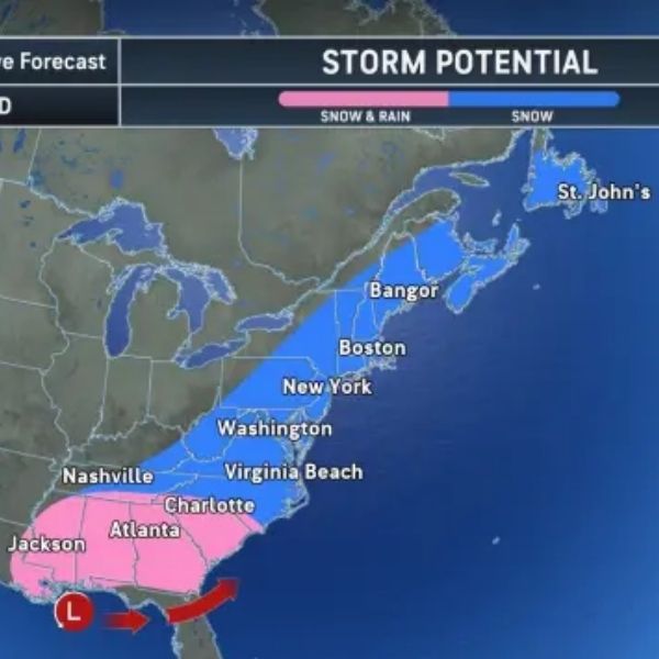
Precipitation could begin as early as Friday along the Gulf Coast, mainly south of Interstate 10 from Louisiana to Florida. Depending on the storm’s timing and strength, snow could mix with rain from I-10 northward across parts of Louisiana, Mississippi, Alabama, and Georgia. Most intense precipitation is expected to largely miss areas already hit by the last storm, with widespread power outages more likely farther north.
As the storm moves east late Friday into Saturday, rain could spread to Florida, with potential wintry weather reaching the Carolinas.
“How fast the storm strengthens will determine its final track this weekend and whether it moves up the East Coast,” Pastelok said.
-
If the storm is weaker or slow to strengthen, it may track along the Gulf Coast and move out over the Atlantic before turning north. Snow would mainly affect the Carolinas and New England, with less risk of widespread heavy snow.
-
A stronger storm is more likely to turn north sooner, raising the risk of snow along the entire Eastern Seaboard. It could develop into a nor’easter, bringing heavy snow from the mid-Atlantic to New England, with stronger coastal winds than the previous storm.
-
An exceptionally quick-strengthening storm could even push snow west to the Appalachians, from North Carolina to Pennsylvania.
A reinforced wave of cold air is expected to follow, keeping temperatures well below average into early February.
“Sub-freezing temperatures may reach as far south as central Florida, creating a potential damaging freeze for citrus crops,” Pastelok said.


Leave a Reply