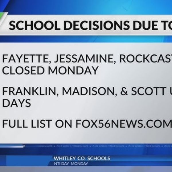
KENTUCKY — Several school districts across Kentucky could experience multiple closures next week as a series of winter storms tracks through the Midwest and Ohio Valley.
Forecasters are monitoring three separate systems expected to affect the region starting this weekend and continuing into midweek.
Although these storms are not projected to reach the strength of the historic blizzard that recently hit parts of the East Coast, they may still create hazardous travel conditions statewide.
The first system is forecast to move mainly north of Kentucky, but some areas could receive light snowfall from late Saturday into early Sunday. Snow totals from this wave are expected to remain minimal.
The second storm poses a greater concern. It is expected to develop Sunday night into Monday as warmer, moisture-laden air from the Gulf overrides colder surface air — a pattern that frequently leads to freezing rain and icy conditions.
Current projections indicate the highest icing risk may target areas along and north of the Interstate 64 and Interstate 70 corridors. However, parts of northern and central Kentucky also remain within the potential impact zone. Forecasters warn that even slight changes in the storm’s track could dramatically shift where snow changes to freezing rain.
Even small amounts of ice can make rural and secondary roads unsafe for school bus travel. Similar weather patterns in the past have triggered multi-day school closures due to persistent ice and overnight refreezing.
A third system is forecast to arrive Tuesday into Wednesday. While some locations could see mainly rain, colder air lingering near the surface may bring additional icing or light snow, particularly in northern Kentucky.
With three winter systems expected in rapid succession, school officials statewide are closely tracking forecasts. Back-to-back rounds of winter weather could lead to multi-day cancellations in some districts.
Families should monitor updates from their local school systems as the forecast becomes more defined in the days ahead.


Leave a Reply