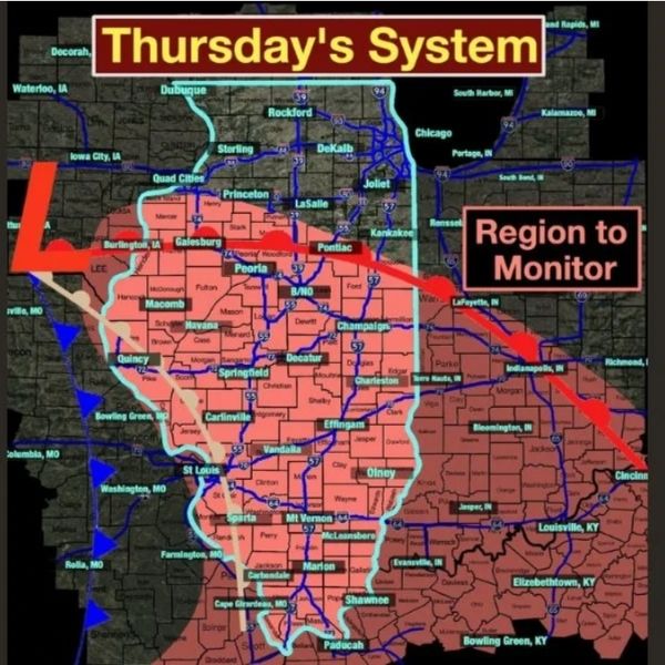
A strong storm system is expected to impact parts of the Midwest Thursday, bringing a two-round severe weather threat across portions of Illinois, Indiana, Kentucky, and Missouri.
Here’s a breakdown of what to expect:
🌩 First Round: Thursday Morning (8 AM – 2 PM)
As a warm front lifts north, storms are expected to develop across central and southern Illinois and nearby areas of eastern Missouri and western Indiana.
Areas to watch in Illinois:
-
Peoria
-
Springfield
-
Decatur
-
Champaign
-
Galesburg
-
Quincy
-
Bloomington
-
Effingham
Potential threats:
-
Strong wind gusts
-
Hail
-
Brief, isolated tornado risk
Forecasters say widespread severe weather is not expected, but isolated stronger cells could intensify quickly, especially near and just south of the warm front.
⛈ Second Round: After 3 PM (Highly Conditional)
A second wave of storms may develop later in the afternoon and evening — but this depends on whether the atmosphere can “recover” after the morning storms.
If redevelopment occurs, all severe modes would be possible:
-
Damaging winds
-
Large hail
-
Isolated tornadoes
Expanded risk areas include:
-
Indianapolis
-
Bloomington
-
Lafayette
-
Louisville
-
Bowling Green
Additional Illinois communities in the broader monitoring zone:
-
Carbondale
-
Marion
-
Mount Vernon
-
Olney
-
Vandalia
⚠️ Overall Risk Assessment
-
Not expected to be a high-end outbreak.
-
Severe threat currently categorized as relatively low.
-
However, conditions could escalate quickly depending on storm organization and atmospheric recovery.
✅ What Residents Should Do
-
Monitor updated forecasts Thursday morning.
-
Enable wireless emergency alerts on your phone.
-
Have multiple ways to receive weather warnings.
-
Be prepared for rapidly changing conditions.
While this is more of a “stay alert” setup than a major outbreak scenario, warm-front-driven systems can produce quick, localized severe weather — especially in late winter across the Midwest,


Leave a Reply