This weather system won’t be nearly as impactful as January’s winter storm, but reduced visibility and slick spots are possible into Tuesday night.
LOUISVILLE, Ky. — On Monday, temperatures in Louisville climbed above the freezing mark for the first time in more than 10 days.
However, any reduction in the snowpack from this brief warm-up was limited and short-lived, as another weather system is expected to move in on Tuesday.
While this system won’t be as severe as January’s winter storm, reduced visibility and slick conditions remain possible through Tuesday night.
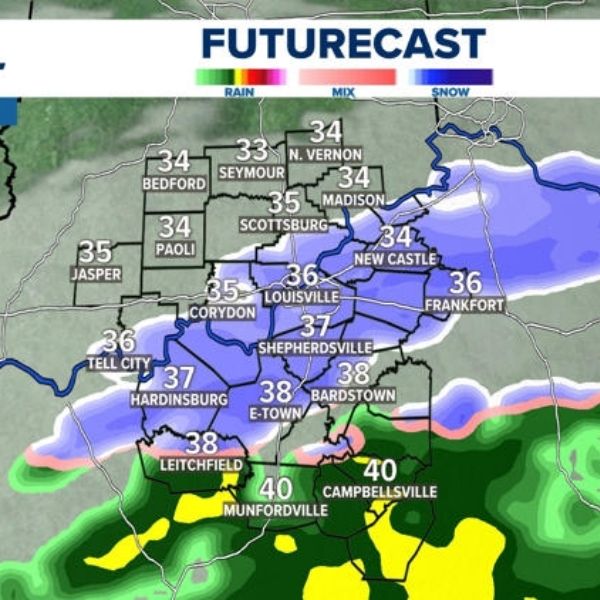
Snow showers are expected to begin later this morning across much of Kentuckiana, with temperatures still hovering around the freezing mark. Warmer air will slowly move in from the south, allowing a transition to sleet showers along the Ohio River and cold rain for counties south of Elizabethtown.
A northern stream of colder moisture in the form of snow will merge with a southern stream bringing rain across the viewing area. This interaction will allow a band of wintry mix to move through Kentuckiana from northwest to southeast. Some counties, especially those south and southwest of the Parkways, may not see any snow at all, with chilly rain likely serving as the primary precipitation type.
Those areas that do receive snow could see around an inch of slushy accumulation, with up to 2 inches possible in parts of southern Indiana, where temperatures are expected to remain colder.
A dusting to an inch of snow is likely along Ohio River counties, though sleet showers later in the afternoon could reduce those totals.
While snow is falling, temperatures may be near or slightly above freezing. However, heavier snow rates could overcome warmer air and ground temperatures, allowing accumulation instead of melting.
Regardless of exact totals, a messy afternoon and evening commute is expected, with a Weather Impact Alert in effect. The National Weather Service has issued a Winter Weather Advisory for areas along and northeast of I-64, where slushy accumulations of one to two inches are possible.
Temperatures are expected to fall into the teens and lower 20s Tuesday night, leading to additional icy spots. A few flurries may linger into Wednesday morning.


Leave a Reply