TENNESSEE — A powerful winter storm is becoming increasingly likely to affect a large portion of the Mid-South and Southeast this weekend, with updated model guidance showing widespread heavy snowfall, notable ice accumulation, and dangerously cold temperatures across several states.
The latest forecast data indicates the system could develop into one of the most disruptive winter storms in years for parts of Tennessee, Kentucky, northern Georgia, and the Carolinas. Meanwhile, nearby areas remain on a narrow margin between heavy snowfall and little to no accumulation.
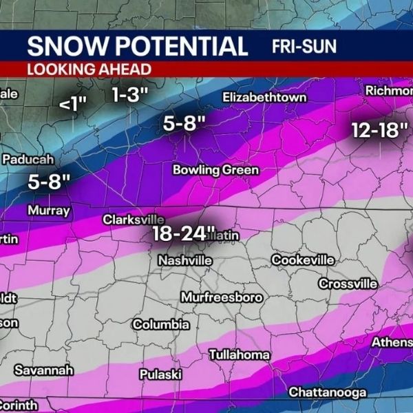
Heavy snow potential centered on Tennessee and the I-40 corridor
Confidence continues to increase that central and western Tennessee will lie near the heart of the storm’s snow axis. Forecast models point to a broad swath of 6–12 inches of snow, with isolated bands potentially exceeding 12 inches.
The I-40 corridor — including Memphis, Jackson, Nashville, and Clarksville — appears particularly at risk if current trends persist. Nashville stands out as a key city to monitor closely. Historically, the city has recorded 10 inches or more of snow only seven times, with the most recent major event delivering 11.3 inches in February 1979. The city’s all-time snowfall record remains 17.3 inches, set in March 1892.
If forecast totals materialize, this storm could rank among the top 10 snowstorms in Nashville’s recorded history.
Sharp snow cutoff adds forecast uncertainty
One of the most difficult elements of this forecast is the exceptionally sharp northern cutoff in snowfall. Models show a rapid transition from more than 12 inches of snow to virtually none within a one- to two-hour drive.
This places parts of southern Missouri, western Kentucky, and southern Indiana in a high-uncertainty zone. Cities including Paducah, Springfield, Joplin, and Evansville could either see significant snowfall or minimal accumulation, depending on small changes in the storm’s track.
The steep gradient is linked to a strong Arctic air mass to the north, which could push the entire system southward at the last minute.
Significant ice threat across Georgia and the Deep South
While snow remains the primary concern farther north, ice could become the dominant hazard farther south, particularly across Georgia, Alabama, and portions of South Carolina.
Forecast guidance highlights metro Atlanta and nearby areas as especially vulnerable to freezing rain and sleet, with enough ice accumulation to cause tree damage, power outages, and dangerous travel conditions. Ice storms in this region often produce greater impacts than snow due to sensitive infrastructure and vegetation.
Bitter cold increases overall risk
Adding to the threat is an incoming surge of extreme cold, with overnight lows expected to drop into the single digits or below zero across parts of Tennessee, Kentucky, and the Mid-South early next week.
If substantial ice accumulates before temperatures plunge, the risk of prolonged power outages increases significantly. Some locations may challenge cold records dating back to the 1960s and 1980s, creating a dangerous combination of ice damage and life-threatening cold.
What still needs monitoring
While confidence remains high that a major winter weather event is approaching, the precise placement of the heaviest snow and ice bands is still uncertain. Small shifts over the next 24 to 48 hours will determine which communities experience historic impacts and which remain just outside the storm’s reach.
Residents across the affected states are urged to closely monitor forecasts and prepare now for rapidly changing conditions, travel disruptions, and potential power outages.


Leave a Reply