Over the past 12 to 18 hours, there have been notable changes in the data for this weekend’s winter storm, which is expected to impact our area in one way or another. Regardless of the exact outcome, a Winter Storm Watch remains in effect for our area from Saturday morning through Monday morning.
What’s changed?
I’m not going to waste your time here. Let’s get straight into it. If you remember our previous blog from Monday about this weekend’s system, we discussed the importance of tracking the storm’s path, since that would determine two key factors: how much snow falls and what type of precipitation we see.
Since yesterday, that path has shifted. As we move closer to the storm’s arrival, the data has improved, and models are now pushing this system much farther north than what was shown even on Tuesday.
So what does this mean for us?
With a shift of more than 100 miles to the north, sleet and possibly some freezing rain are now being pulled farther north as well. The system is expected to begin as snow, as temperatures from the surface to the cloud layer will be cold enough at the onset.
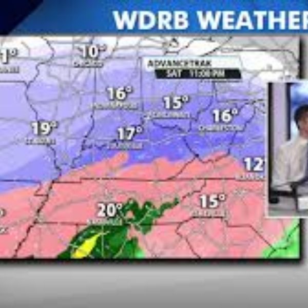
As the event progresses, sleet begins to move in.
Notice how close that sleet is to our area now. That is extremely important.
The latest data suggests sleet is becoming more likely for many Kentucky counties and is pushing very close to the Louisville area. Accurately pinpointing where this sleet line sets up matters because the heaviest snow totals typically occur just north of it.
At this point, much of the data places the sleet line just south of Louisville, which would position the heaviest snow along the Ohio River.
Pump the brakes.
Just because current data shows the heaviest snow band near the Ohio River does not mean it will stay there. We just witnessed a 100 to 150-plus mile northward shift almost overnight. There is nothing to say that the sleet line cannot still move farther north or south. Wherever sleet mixes in, snow totals will be significantly reduced.
So what’s next?
The next step is simple: closely monitoring trends in the data over the next 24 to 48 hours to determine where that sleet line ultimately sets up and how far north or south it travels. That placement could be the deciding factor between significant snowfall and a disappointing outcome dominated by sleet.
When looking at atmospheric soundings for Louisville on Saturday evening, winds about a mile above the surface are coming from the south and moving at a decent speed. This often signals warm air aloft working into the atmosphere.
If temperatures rise above freezing at that level, sleet becomes likely. This occurs when snowflakes partially melt and then refreeze before reaching the ground. This remains a real possibility for Louisville. If a warm layer, often referred to as a “warm nose,” develops, sleet could dramatically cut into snowfall totals.
This is where the boom-or-bust scenario comes into play. Areas just north of the sleet line could see very high snow totals, but the big question remains: where does that line end up? That is what we will be closely watching over the next couple of days before issuing any snow totals.


Leave a Reply