United States — Long-range weather guidance continues to point toward a more active and colder winter pattern returning across much of the central and eastern United States late next week. Parts of the Midwest, Southeast, and Mid-Atlantic could face another round of winter weather impacts. While it remains too early to determine snowfall totals or pinpoint exact impact areas, several signals suggest conditions may turn favorable for wintry precipitation as colder air moves south and interacts with an active storm track.
Colder-than-normal temperatures spreading east and south
Forecast temperature probability maps for the 6–10 day period show a strong signal for below-average temperatures extending from the northern Plains through the Midwest and into the Ohio Valley, Southeast, and Mid-Atlantic. States such as Illinois, Indiana, Missouri, Kentucky, Tennessee, Georgia, the Carolinas, Virginia, and Pennsylvania are increasingly likely to see colder air by late next week.
In the Midwest, the cold could be intense, with dangerously low wind chills possible, especially in open and rural locations. Farther south, temperatures may remain close enough to freezing to support snow, sleet, or freezing rain if moisture moves into the region.
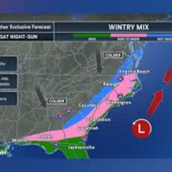
Storm track favors a Southern Plains to East Coast setup
Medium-range model guidance shows an active storm corridor developing from the Southern Plains eastward into the Southeast and Mid-Atlantic. This pattern raises concern because it places several areas near the dividing line between colder air to the north and warmer air to the south, a classic setup for mixed winter precipitation.
If this pattern holds, snow would be more likely north of the storm track, while sleet or ice could become an issue farther south, especially across parts of Georgia, South Carolina, North Carolina, and Virginia. Ice accumulation remains a significant concern in these scenarios, even when snowfall amounts are uncertain.
Why specific impacts remain unclear
At this range, roughly 7 to 10 days out, forecasters are not trying to project snowfall totals, precise locations, or travel impacts. Instead, the focus remains on identifying the overall pattern:
The large-scale setup supports winter weather potential
Cold air appears strong and persistent
Storm energy remains active
Key details such as timing, storm intensity, and exact placement are still uncertain. Small temperature changes of just a degree or two can dramatically alter outcomes, particularly in the Southeast and Mid-Atlantic where rain, snow, and ice lines are often very narrow.
What forecasters will monitor next
As the system moves into the 5–7 day window, meteorologists will begin looking for agreement among models on:
Storm timing and track
Strength and durability of the cold air
Whether precipitation aligns with the coldest temperatures
Within 3–5 days, clearer guidance on precipitation type usually develops. Snowfall or ice amounts typically cannot be discussed with confidence until 1–3 days before an event.
Bottom line for now
This pattern currently fits into the “possible winter storm” category. It is not a guaranteed event, but it is not something to dismiss either. The setup supports cold and active weather, suggesting multiple chances for winter systems over the next couple of weeks.
Residents across Illinois, Georgia, the Carolinas, Virginia, and nearby states should stay informed, keep plans flexible, and remember that long-range forecasts are meant to raise awareness, not trigger alarms.
Forecast confidence should improve later this week as model agreement increases and more details become clear.


Leave a Reply