A fast-moving coastal storm is set to impact the East Coast with snow and sleet.
The system is expected from Sunday afternoon, Jan. 18, into Martin Luther King Jr. Day morning, Jan. 19, potentially causing travel disruptions from the Carolinas to New England, according to the National Weather Service.
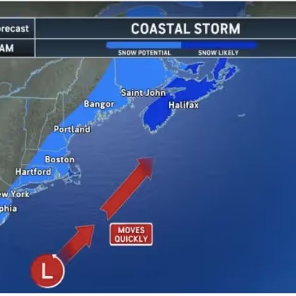
AccuWeather forecasters say the storm will develop off the Southeast coast and race northeast, with accumulating snow possible in cities including Richmond, Philadelphia, New York, Hartford, and Boston. The exact track remains uncertain, and even a slight shift could determine whether major cities see just a dusting or several inches of snow.
The highest chance for accumulating snow stretches from eastern North Carolina and Virginia up through New Jersey, southeastern New York, and southern New England. While the storm is expected to move quickly, it still poses a threat for slick roads and flight delays, particularly along the busy I-95 corridor.
AccuWeather graphics show a broad zone of “snow potential” along the coast, with “snow likely” for parts of eastern Maine, New Brunswick, and Nova Scotia as the storm intensifies offshore. Cities such as Bangor, Saint John, and Halifax could see the heaviest snow if the storm hugs the coast.
Meteorologists warn that even light snow can create hazardous travel conditions. “Road conditions can deteriorate rapidly when snow bands move through. Drivers should slow down and increase following distance. Sudden drops in visibility and slippery roads are a dangerous combination,” said AccuWeather Meteorologist Brandon Buckingham.
The storm will follow a powerful cold front that moved through the region on Thursday, Jan. 15, bringing Arctic air and setting the stage for a wintry weekend. Temperatures will remain well below normal, and gusty winds will make it feel even colder.
If the storm tracks closer to the coast, snow totals could rise, especially in the Poconos, Catskills, and Berkshires. If it stays farther offshore, impacts may be limited to light snow and gusty winds.
Travelers and residents are advised to monitor forecasts and prepare for potential delays and slippery conditions. Updates are expected as the storm’s path becomes clearer.
A separate system could bring light snow Friday night, Jan. 16, into Saturday, Jan. 17, with 1-3 inches possible in western Pennsylvania and western and upstate New York.


Leave a Reply