NASHVILLE, Tenn. (WKRN) — Winter is making a noticeable return across Middle Tennessee and southern Kentucky, with cold conditions expected to last the next seven to 10 days. Multiple waves of cold air will move through the eastern United States, bringing temperatures well below seasonal averages.
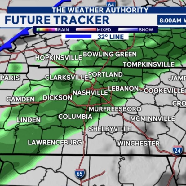
On Wednesday, a cold front will push into the News 2 viewing area during the midday and afternoon hours. Rain will move through ahead of the front, while temperatures fall from the 40s and 50s into the 30s by late afternoon, then drop below freezing during the evening. As temperatures decline, higher elevations in far eastern Middle Tennessee may see rain change over to snow. Most locations are not expected to see snowfall, but areas that do could receive a light coating to up to an inch.
All precipitation is expected to exit the area by Thursday morning. The primary concern on Thursday will be bitterly cold temperatures combined with strong northerly winds. Wind chill values are forecast to fall into the single digits across much of the region.
Another surge of cold air is expected to arrive this weekend. New forecast models are now introducing the possibility of a wintry mix from Friday into early Saturday. Updated high-resolution model data shows a wintry mix developing Friday afternoon and evening, especially north of Interstate 40. The European model suggests a similar setup but with significantly less precipitation.
With cold air firmly in place, there is potential for an overrunning event, where warmer air moves over colder surface air and produces precipitation, a scenario the European model may be underestimating. For now, forecasters are maintaining a 40% chance of precipitation on Friday. Additional updates are expected as the system develops.


Leave a Reply