UNITED STATES — A widespread and potentially impactful rain pattern is expected to take shape during the first week of April, placing much of the central and eastern United States at risk for extended periods of rainfall. This setup could deliver multiple rounds of storms over several days, raising the chances of higher totals and localized flooding concerns across the region.
The forecast for April 1 through April 7 highlights a broad corridor where repeated storm systems may pass over the same areas, allowing rainfall to build gradually instead of occurring in a single event.
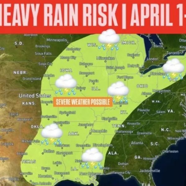
Wide Multi-State Area Under Threat
The risk zone stretches from Texas northeastward through Arkansas, Louisiana, Mississippi, Alabama, Tennessee, and Kentucky. It then extends into Illinois, Indiana, Ohio, Michigan, and Pennsylvania, covering large portions of the Midwest and Great Lakes.
This widespread coverage points to a well-organized weather pattern capable of affecting multiple regions at once, rather than a single isolated system. Communities throughout this corridor may see several rounds of rain, which can increase overall accumulation.
Rainfall Totals May Reach 2 to 5 Inches
Forecast guidance suggests rainfall totals could range between 2 and 5 inches in some areas, particularly where storms repeatedly track over the same locations. These amounts are notable, especially over multiple days, and may lead to saturated ground conditions.
In some spots, totals could exceed these levels if stronger storms develop or stall, producing heavier rain in shorter periods.
Repeated Storm Rounds Likely
The overall pattern indicates storms may move in waves across the same regions over several days, often described as a “training” setup, where storms follow a consistent path.
Even moderate rainfall can accumulate quickly under these conditions, increasing the likelihood of water buildup and reducing the ground’s ability to absorb more rain.
Severe Weather Also a Possibility
In addition to heavy rainfall, parts of the region could experience strong to severe thunderstorms. These storms may bring hazards such as gusty winds, lightning, and bursts of intense rain.
While rainfall remains the primary concern, thunderstorms could cause more severe impacts in localized areas over short periods.
Flooding Risk May Rise in Vulnerable Areas
With several inches of rain possible, localized flooding risks will increase, especially in flood-prone locations. Low-lying areas, urban regions with limited drainage, and communities near rivers or streams may face higher vulnerability.
Flooding will not occur everywhere, but areas experiencing repeated heavy rainfall could see rising water levels, particularly if drainage systems become overwhelmed.
What to Expect Next
Forecast models will continue refining the timing, placement, and intensity of rainfall as the event approaches. Even small shifts in storm tracks could determine where the heaviest rain falls.
Residents across Texas, the Lower Mississippi Valley, the Midwest, and the Great Lakes should stay alert and monitor updates as this prolonged rain event develops in the coming days.


Leave a Reply