Warm temperatures and gusty winds are expected on Wednesday.
A strong cold front will drop temperatures into the 40s by Thursday.
Quiet and cooler days are expected as the weekend approaches.
LEXINGTON, Ky. (FOX 56) — Warmer temperatures will linger for one more day, but they will also bring gusty winds and the possibility of several rounds of storms.
Highs on Wednesday will reach the mid-70s before a powerful cold front moves across the state late in the day, sending temperatures down to the 40s by early Thursday.
Southwest winds of 15 to 25 mph with gusts exceeding 35 mph are likely outside of thunderstorms ahead of the front. Winds will shift to the west-northwest and remain breezy into Thursday.
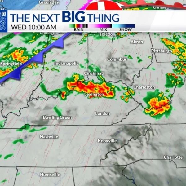
Several rounds of storms could develop on Wednesday.
Storms early in the morning may bring damaging wind gusts and heavy rainfall. There is a slight chance of severe weather early, but the risk remains low.
The evening round has a higher potential to produce damaging straight-line winds and may also carry an isolated tornado threat. Hail appears to be more of a secondary concern with this setup.
A level 2 of 5 risk for scattered severe storms covers the entire area. Make sure your alerts are turned on tomorrow.
The key factor to watch tomorrow is how much the morning storms affect the atmosphere’s ability to recover before the evening round.
If storms linger, they could limit the potential for evening storms. However, if the area dries out sooner and sees some sunshine, the chances for severe storms later in the day will increase.
The main line of storms on Wednesday is expected to move through the area between 4 p.m. and 10 p.m., which is the most likely window for scattered severe weather.
Storms will gradually weaken overnight into early Thursday, and high pressure will begin clearing skies, bringing some sunshine by Thursday afternoon. As mentioned, temperatures will be much cooler.
A few quiet days will follow heading into the weekend, with lows in the 30s and 40s and highs returning to the low 60s on Friday and Saturday.
A strong warm front will push temperatures back toward 70 on Sunday, but another cold front will bring winter-like temperatures back at the start of next week.
During that time, a line of rain showers will move through the area and may gradually transition into a chance for snow showers as colder air arrives aloft.


Leave a Reply