Another round of winter weather is heading toward the United States, set to affect at least 25 states and deliver snow showers as far south as North Carolina and Tennessee. Lake-effect snowbelts in the Midwest and the interior Northeast are once again expected to see the highest accumulations.
Forecasters initially expected a large clipper system moving toward the Great Lakes on Tuesday to develop into a complex winter storm capable of producing heavy snowfall across much of the East. However, a surge of warm air ahead of the system is now expected to change much of the precipitation to rain instead of snow, with that rain spreading across the East Coast by Wednesday.
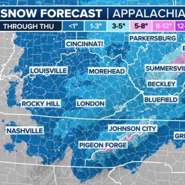
Complex storm targets the Appalachians, potential impacts near the I-95 corridor
As the fast-moving clipper pushes southward, the cold front trailing behind it will become the main driver for rain and snow. While this setup reduces the chance of a major snowstorm, impacts are still expected across several regions, including parts of the Ohio Valley, where scattered snow showers are possible.
Farther east, snow showers may develop depending on how quickly colder air arrives and how much moisture remains. Accumulation appears less likely due to warmer and wetter conditions ahead of the system, though brief bursts of snow could still cause sudden travel issues if visibility drops quickly. Areas along the I-95 corridor are expected to see minimal impacts.
Back-to-back systems to bring more snow and ice to the northern U.S.
As the storm moves east, colder air pouring in behind it will support lake-effect and lake-enhanced snow around the Great Lakes, as well as upslope snow across the Appalachians.
The Lake Michigan shoreline from western Michigan toward the Indiana-Illinois border is expected to be particularly impacted, especially if winds shift from southerly to northerly. The FOX Forecast Center said snow is likely to begin late Wednesday and continue into Thursday, with moderate to heavy totals ranging from 8 to 12 inches.
The National Weather Service has issued a winter storm watch for the southern shore of Lake Michigan, including South Bend, Indiana, from Wednesday through Thursday.
Additional lake-effect and lake-enhanced snowfall is expected near Lake Superior around Marquette, along with areas near Lake Erie, Lake Ontario, northern Pennsylvania and upstate New York.
Forecast uncertainty remains tied to wind direction, particularly whether winds turn northerly or northwesterly, which would determine where the heaviest snowfall sets up.
The storm is expected to move into the Appalachians late Wednesday, primarily affecting mountainous areas. As winds shift to the northwest, snow showers will intensify into early Thursday. Upslope snow is forecast across higher terrain from the Tennessee-North Carolina border north into West Virginia and along the highest peaks of the Appalachians.
West of the mountains, some areas could see light snow, while locations east of the range may experience only a few light rain showers. At this time, widespread heavy snow is unlikely outside the highest elevations due to warmer temperatures.
Most accumulating snow is expected from early Wednesday through Thursday morning, before tapering to flurries by Thursday afternoon.


Leave a Reply