A warm-up is underway across East Tennessee this Sunday, with plenty of sunshine and dry conditions expected to continue for the next couple of days before a more unsettled weather pattern arrives.
Today: Dry air, light breeze, and warmer temperatures with an elevated fire risk. High near 69°.
Tonight: Milder and calm. Low around 49°.
Monday: Warmer and breezy with increasing clouds. High near 74°.
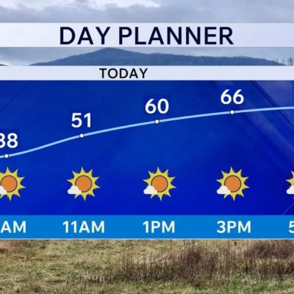
After a chilly start this morning, dry air and mostly sunny skies will help temperatures climb quickly, with many areas reaching the upper 60s to near 70°. However, the combination of dry conditions, a southerly breeze, and ongoing drought will keep fire danger elevated, meaning fires could start and spread بسرعة.
Tonight will be milder, with temperatures staying in the upper 50s through the evening before dipping into the upper 40s to low 50s by Monday morning. Winds will remain light overnight before picking up again on Monday.
The warming trend continues into Monday, with breezy southerly winds pushing highs into the low to mid-70s under partly cloudy skies. Most areas will stay dry, although a stray sprinkle is possible in parts of Kentucky as moisture begins to increase. Overnight lows will only fall into the upper 50s as humidity rises.
By Tuesday, a mix of sun and clouds and gusty winds — possibly exceeding 30 mph, especially across the Plateau — will push temperatures into the upper 70s to near 80°. It will feel more humid, but conditions are expected to remain dry. Tuesday night will stay mild and muggy, with lows in the lower 60s.
Next Weathermaker: A wetter and more active pattern arrives mid-to-late week.
Wednesday will bring continued warmth with highs in the upper 70s to near 80°, along with a chance for afternoon and evening showers or storms. While severe weather is not expected at this time, some storms could produce gusty winds and small hail.
Thursday and Friday will remain warm, with highs in the mid-70s, but conditions will stay unsettled with daily chances for scattered showers and thunderstorms. While not a washout, rain chances will persist each day — welcome news for areas still needing rainfall.
The risk for severe weather remains low for now, though conditions will be monitored.
Looking ahead to Easter weekend, temperatures are expected to stay warm in the upper 70s to low 80s, with continued moisture bringing at least some chances for rain.


Leave a Reply