Afternoon highs will climb back into the 70s by late week
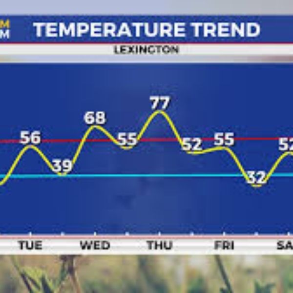
After record-setting temperatures and a summer-like feel to close the weekend, with afternoon highs reaching the mid to upper 80s across Central and Eastern Kentucky, cooler air returned to the Ohio Valley on Monday for a quick reality check. A brisk northwest wind pushed in the cooler air along with lingering clouds behind a departing cold front, dropping morning temperatures into the low 40s, making a jacket necessary early. As the day progressed, sunshine returned, helping afternoon highs recover into the low 50s.
Expect a cold start to Tuesday, with temperatures in the low to mid-30s, a reminder that it is still early spring before a pleasant late March day unfolds. High pressure will sit to the northeast, bringing a mix of clouds and sunshine along with a steady east breeze. Afternoon highs should rise a few degrees into the mid-50s but remain slightly below average for late March, as the east wind keeps the cooler air mass in place.
Heading into midweek, a quiet and calm weather pattern will continue as the area of high pressure drifts east. This will allow a return flow on the backside of the high, shifting winds to the south. Combined with increased sunshine, afternoon highs should rebound quickly, climbing into the upper 60s to around 70 degrees, especially in southern areas. A weak disturbance may pass through on Thursday, bringing a slight chance of showers, but most areas should stay dry. A strong southwest flow ahead of a cold front moving through the Ohio Valley will bring another surge of warm air, pushing afternoon highs into the upper 70s.
Shower and storm chances will increase Thursday night into Friday as the cold front moves through, leading to a wetter and cooler end to the week. Depending on the timing of the front, temperatures may not rise much on Friday, with highs in the 50s and possibly falling through the afternoon as cooler air returns to the region. High pressure will settle in for the weekend, bringing sunshine but another round of cooler air, with highs dropping into the low 50s on Saturday. Temperatures should recover slightly by Sunday, reaching around 60 degrees, with a warming trend continuing into early next week.
torm Team 3 Day Forecast
Monday night: Expect a few clouds and cold conditions. Lows in the low 30s. Wind: NE 5-10 mph.
Tuesday: Expect partly sunny and pleasant conditions. Highs in the mid-50s. Wind: E 5-10 mph.
Tuesday night: Expect scattered clouds and continued chilly conditions. Lows in the upper 30s and low 40s. Wind: E 5 mph.


Leave a Reply