KENTUCKY — A fast-moving line of thunderstorms is expected to move across Kentucky on Saturday, with forecasters warning that damaging straight-line winds could be the main threat as the system approaches from the west. Early model guidance, including the high-resolution HRRR weather model, indicates a squall line forming across the Mid-South and racing northeast through the Ohio Valley, putting much of Kentucky in its path.
Meteorologists tracking the developing system say timing will be a key factor in determining how strong the storms become. Current forecasts suggest the line could reach western Kentucky sometime between mid-morning and early afternoon.
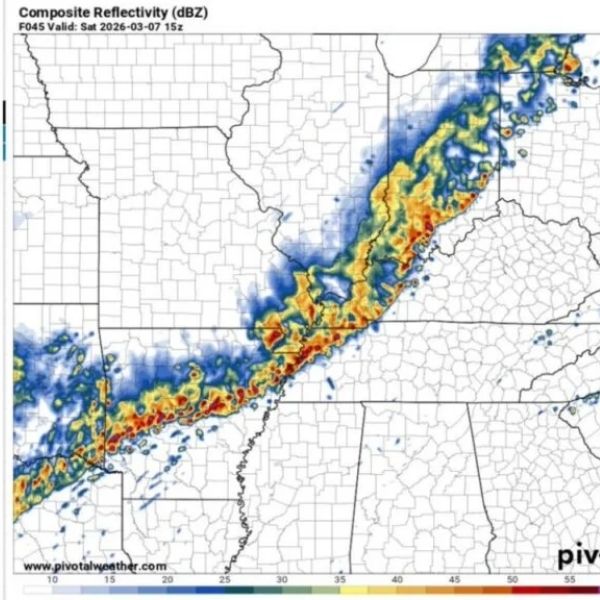
Storm Line Expected to Enter Kentucky From the West
Weather model simulations show a long, organized band of thunderstorms stretching from Arkansas through western Tennessee and into the Mississippi Valley, gradually moving northeast. As the line advances, it is expected to cross the Mississippi River and move into western Kentucky before continuing toward central and eastern parts of the state.
Radar simulations show a classic squall line structure, which often produces widespread wind damage as storms organize into a fast-moving band.
Communities such as Paducah, Murray, Hopkinsville, Bowling Green and areas near the Land Between the Lakes region could be among the first to see the storms before they continue toward Lexington, Frankfort and Louisville later in the day.
Forecasters note that squall lines often move faster than forecast models initially predict, meaning the storms could arrive earlier than expected.
Damaging Winds Highlighted as the Primary Risk
Analysis of atmospheric soundings from the model data suggests that strong winds higher in the atmosphere could mix down to the surface, increasing the chance of damaging gusts.
The storm environment shows:
Strong wind shear throughout the atmosphere
A linear storm structure that favors wind damage
Limited instability compared with major tornado outbreaks
Because of these conditions, meteorologists say widespread wind damage is the most likely hazard, although isolated stronger storms could still produce brief severe conditions.
Wind gusts in the strongest storms could reach 50 to 70 mph, which may bring down tree limbs, cause scattered power outages and create hazardous travel conditions during heavier rain.
Timing Could Influence Severe Potential
One of the biggest uncertainties remains the exact timing of the storms.
Some forecast models suggest the storms could arrive during the mid-morning hours, while others indicate they may move into Kentucky closer to early afternoon.
If storms arrive earlier in the day, limited daytime heating could reduce the instability available in the atmosphere, slightly lowering the severe weather risk.
However, if the line arrives later in the afternoon, additional atmospheric energy could strengthen the storms and increase the chance of damaging winds.
At this point, many meteorologists believe a mid-morning arrival is the most likely scenario, which could limit the overall intensity but still bring a period of strong storms across the state.
Fast-Moving Storms Could Reduce Warning Time
Another concern with squall line events is speed. These storms often move quickly, giving communities less time to respond once warnings are issued.
Residents across Kentucky are encouraged to:
Monitor local weather alerts Saturday morning
Have multiple ways to receive severe weather warnings
Secure loose outdoor items that could become airborne in strong winds
Although the storms are expected to pass through relatively quickly, the brief period of intense wind and heavy rain could still cause localized damage.
Another Active Weather Day for the Ohio Valley
The approaching system is part of a broader weather pattern bringing repeated storm chances across the central United States and the Ohio Valley this week.
As the squall line moves northeast, storms could continue into southern Indiana, Ohio and parts of West Virginia later Saturday, extending the threat beyond Kentucky.
Meteorologists say they will continue monitoring conditions closely as new model data arrives over the next 24 hours, which may refine the forecast timing and intensity.


Leave a Reply