A fast-moving stretch of late-winter weather is lining up to bring repeated snow chances, sharp temperature swings and even the possible return of severe storms in parts of the South, according to meteorologist Max Schuster of the YouTube channel Max Velocity – Severe Weather Center.
In his latest forecast video, Schuster describes what he calls a “huge snow train” targeting the United States, with multiple systems expected to track through the Midwest, Ohio Valley, Great Lakes and Northeast over the next week. He emphasizes that this is not just about additional snowfall, but about an unusually active and messy pattern that can shift quickly as each wave moves through.
That distinction matters because this is not a one-and-done setup. Schuster outlines a sequence: lighter snow in the short term, another round later in the week and a more uncertain but potentially stronger system as the calendar flips to early March.
He also notes that this pattern follows a major Northeast blizzard, meaning even moderate additional snowfall could create outsized impacts since so much snow already covers parts of the region.
Historic Blizzard Sets The Stage For What Comes Next
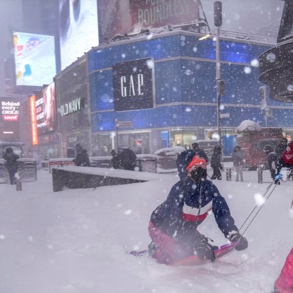
Schuster opens by recapping the powerful Northeast storm that just swept through. He calls the nor’easter “downright historic,” saying some areas picked up nearly 40 inches of snow, with widespread totals of 20 to 30 inches from New York City east across Long Island and into southern New England.
He highlights especially extreme totals in Rhode Island, noting areas near Providence and Warwick reached about 38 inches, surpassing Providence’s famous 1978 blizzard snowfall record. He also points to heavy snow south of Boston and near Plymouth, where both snow and wind caused significant impacts.
He explains that snowfall totals varied, as often happens in major winter storms where small shifts in banding can dramatically change local outcomes. Still, he makes it clear that the storm was a major event and reset the baseline for what residents across the Northeast must now manage.
With deep snowpack already in place, even a few additional inches can worsen travel problems, slow cleanup efforts and add stress to roofs, sidewalks and local infrastructure still recovering from the first storm.
The “Snow Train” Pattern Across The Midwest, Ohio Valley, And East
After reviewing the blizzard, Schuster shifts to what he calls the larger story: a broad pattern change likely to affect much of the country through late February and into early March.
He describes a setup featuring a dip in the jet stream near the East Coast, Arctic air spilling south from Canada and a strong west-to-east flow across the western and central U.S. Smaller disturbances dropping in from Canada will help trigger a series of winter systems.
According to Schuster, these ingredients favor repeated Alberta Clippers and other systems capable of spreading snow across the Great Lakes, Ohio Valley, Midwest and East Coast.
He uses the phrase “winter storm train” intentionally. Instead of one dominant storm, he expects several systems — some weaker, some stronger — arriving in relatively quick succession.
He says the first clipper is already forming over the upper Midwest and parts of Canada, while an atmospheric river is soaking the Pacific Northwest with coastal rain and mountain snow. That western moisture could later feed a stronger system as energy shifts eastward.
For the initial clipper, Schuster expects snow showers from parts of Wisconsin and Michigan into northern Illinois, followed by lighter snow spreading into the Ohio Valley and Northeast. Many areas may see 1 to 3 inches, with localized 3 to 6 inch totals possible near the lakes, including areas around Lake Erie and Lake Ontario.
He stresses that this first round will not rival the recent nor’easter, offering a measured perspective instead of labeling every system as a major storm.
Another Late-Week System Could Bring Snow North And Severe Weather South
Schuster then turns to the next system, which he describes as a mixed-impact setup. Moisture from the western atmospheric river combined with energy crossing the Rockies could help form a stronger storm pushing into the central and eastern U.S. by Thursday.
He expects an elongated swath of snow stretching from the northern Plains and Upper Midwest eastward, while areas farther south may face thunderstorms.
He says the Storm Prediction Center is monitoring parts of the Tennessee Valley and Dixie Alley for possible severe weather, including damaging winds and a limited tornado threat. He specifically mentions Georgia, Alabama, Mississippi and southeastern Tennessee as areas to watch.
This sharp contrast — winter weather on one side and springlike severe storms on the other — reflects classic late-winter behavior. Schuster describes the entire pattern as a “temperature roller coaster.”
Along the East Coast, he expects another round of snow from around Maryland into New Jersey, Long Island and southern New England. He does not classify it as a nor’easter but says it could still add a few more inches atop existing snow.
With limited melting expected, those additional rounds may build on current snowpack rather than disappear quickly.
Early March Could Turn More Significant, But Uncertainty Is Still High
Looking toward early March, Schuster signals increased potential but also greater uncertainty.
He outlines another Alberta Clipper followed by Arctic high pressure, then the possibility of a more substantial winter storm developing across the Midwest, Ohio Valley and Northeast in the first days of March. Model guidance suggests a broad area of snow, sleet and freezing rain could form from parts of Iowa into Kentucky and Illinois before possibly strengthening farther east.
However, he emphasizes that storm evolution remains uncertain, particularly regarding how quickly it develops and how much moisture it can access. Several days out, small model shifts can significantly alter track, precipitation type and totals.
He also notes that the Climate Prediction Center has highlighted an elevated chance of another winter storm in early March, with a slight risk of heavy snow in the Northeast. While not a guarantee, it reinforces the active pattern.
Schuster projects a few inches of snow for parts of the Midwest and northern Plains, including Wisconsin, Iowa, the Dakotas and northern Illinois, with lighter snow midweek in the Northeast followed by a potentially more noticeable round into the weekend. He suggests 2 to 5 inches could fall in parts of the Northeast by weekend, while cautioning totals may trend higher as forecasts refine.
Throughout the video, he reiterates the same theme: even if no single round is historic, repeated systems can add up, stacking disruptions and increasing impacts.
A Wild Temperature Roller Coaster Adds Another Layer Of Risk
Snow is only part of the forecast. Schuster also details dramatic temperature swings that may affect areas outside the heaviest snow zones.
He says an Arctic blast is already gripping much of the eastern U.S., pushing unusually cold air deep into the Southeast, including Florida, Georgia and South Carolina. But that cold air will retreat quickly, with warmth rebuilding across the Plains and Southwest before another surge of cold presses into the northern tier.
Rapid warmups can trigger melting and refreezing, complicating road conditions and storm timing. Schuster notes that springlike warmth may spread across the Great Plains and into the Ohio Valley later in the week, even while winter holds firm farther north and east.
He also points to very warm readings in Texas, potentially nearing the 90s by late weekend, highlighting how sharply divided the country could feel. Some regions will prepare for snow and cold, while others brace for warmth and possible severe weather.
By early March, he says, the jet stream may begin lifting north more frequently, gradually shifting winter storm tracks northward while opening the door to more frequent severe weather setups as spring approaches.
The bottom line from Max Velocity’s forecast is that winter is not finished, particularly for the Northeast, Great Lakes and parts of the Midwest. With an active pattern ahead, residents should continue monitoring updated forecasts rather than relying on a single outlook.
Schuster’s “snow train” description may sound dramatic, but based on his analysis, it reflects a practical assessment of a pattern featuring multiple systems, shifting hazards and enough uncertainty to keep both forecasters and residents on alert.


Leave a Reply