SOUTHERN UNITED STATES — A powerful squall line tore across the Deep South, moving from Arkansas into Mississippi and Tennessee and unleashing widespread damaging winds along with multiple tornadoes.
Moderate Risk Issued Across the Mid-South
The Storm Prediction Center placed portions of Mississippi, western Tennessee, eastern Arkansas, northern Louisiana and western Alabama under a Moderate Risk, highlighting the threat of organized severe storms.
The most intense severe weather developed from central Mississippi into western Tennessee, where atmospheric conditions strongly favored damaging winds and embedded tornadoes. Forecasters also included surrounding areas in a broader Slight Risk zone.
Widespread Wind Damage Reports
As the squall line strengthened and advanced east, it produced more than 350 damaging wind reports, ranking it among the region’s more extensive wind events.
The storms tracked from eastern Arkansas through Mississippi and into Tennessee, with impacts extending into parts of Alabama and Kentucky. Cities including Little Rock, Memphis, Jackson and Nashville recorded strong to severe wind gusts as the system moved through.
The storm structure took on the appearance of a classic bowing squall line, capable of producing widespread straight-line wind damage across several states.
Thirteen Tornadoes Confirmed, Five Rated EF2
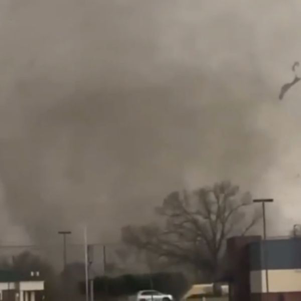
Alongside the wind damage, the outbreak spawned 13 confirmed tornadoes, including five rated EF2 in strength.
Most tornado tracks occurred across Mississippi and Tennessee, with additional touchdowns reported in Arkansas and Alabama. Several tornadoes damaged structures, particularly in rural communities and smaller towns.
Although the event was intense, officials reported no fatalities, though some injuries occurred.
Radar Signatures Showed Embedded Circulations
Radar imagery across the Tennessee Valley revealed strong reflectivity cores and pronounced velocity signatures embedded within the squall line.
Near Nashville and nearby areas, radar scans displayed classic bowing segments and tight wind couplets, indicating zones capable of producing tornadoes and damaging straight-line winds.
Strong wind shear combined with abundant Gulf moisture to fuel a fast-moving yet highly impactful severe weather outbreak.
This article has been carefully fact-checked by our editorial team to ensure accuracy and eliminate any misleading information. We are committed to maintaining the highest standards of integrity in our content.


Leave a Reply