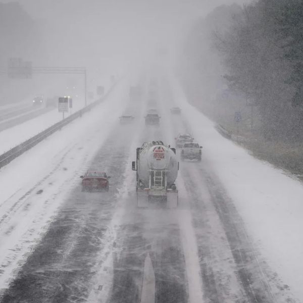
A powerful winter storm is set to slam the Northeastern United States, with a heavy snow band expected to dump 10 to 20 inches from Maryland to Maine over the next 24 hours.
The National Weather Service has issued winter storm and blizzard warnings stretching from the Central Appalachian Mountains to coastal Maine.
“As the low center begins to explosively develop late afternoon and tonight, light to moderate snowfall this morning is expected to rapidly increase in coverage and intensity along the I-95 corridor north of Washington D.C., where snowfall rates will eclipse 2-3″ per hour at times,” the NWS said.
“When combined with strong wind gusts upwards of 40-70 mph, blizzard conditions will quickly materialize from the Eastern Shore of Maryland through southeastern New England, making travel extremely treacherous in these areas.”
National Weather Service Upgrades to ‘Extreme’ Warning
As the storm intensifies, the National Weather Service upgraded its alerts for several states. Parts of Connecticut, Pennsylvania, New Jersey, New York, Rhode Island and Massachusetts are bracing for heavy snow and dangerous winds.
“The latest Winter Storm Severity Index highlights areas including southeast PA, NJ, Long Island, RI, and southeast MA as having the highest impact level. This means extensive and widespread disruptions to daily life, as well as dangerous or impossible travel,” the National Weather Service announced on social media alongside a map.
Up to 36 Inches of Snow, 80 MPH Winds Expected
Most states in the storm’s path are forecast to receive 12 to 18 inches of snow. However, the latest outlook from AccuWeather indicates some areas could see up to three feet.
“Near the coast from New Jersey and Long Island, New York, through southeastern New England, 12-18 inches of snow is forecast with an AccuWeather Local StormMax of 36 inches. Depending on small changes in the storm strength and track, 12-18 inches of snow is possible in coastal Delaware and Maryland as well,” the AccuWeather forecast said.
Meteorologist Max Velocity said “wind gusts between 50-80 MPH, beginning late Sunday and ending late Monday,” are likely to produce blizzard conditions.
Heavy snow and powerful winds are also expected to trigger widespread power outages.
“The clinging nature of the snow and high winds will put a strain on trees and power lines, with extensive power outages anticipated,” AccuWeather Meteorologist Alex Duffus warned.
The National Weather Service also cautioned about the weight of the snowfall.
“Additionally, the weight of this snowfall due to ample liquid content is also forecast to lead to Major Impacts from NJ to MA. Tree damage and downed power lines are possible, including potentially compromising the roofs of poorly constructed buildings,” it said.


Leave a Reply