How about today? What a treat! Temperatures climbed well into the 60s, and some spots even reached the 70s — in February? YES!
If you enjoyed it, soak it in, because by tomorrow morning, we’ll be back to reality. Before that colder air settles in, some areas will see rain tonight.
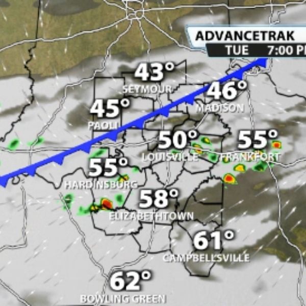
A front moving through the region will quickly shut down the warm air we experienced today. That same front will trigger showers — and possibly a few storms — after sunset. Let’s break it down.
Showers will begin developing near the Ohio River and areas south around 7 p.m. Indiana will likely stay mostly dry. It’s a close call whether Louisville sees any rainfall, but chances look better south of the city.
As the front pushes farther south, downpours — and possibly a few storms — will increase across Kentucky counties.
The system should move out quickly by around midnight. Behind it, colder air will begin pouring in.
By Wednesday morning, temperatures will hover near freezing, and wind chills could dip into the 20s as you head out the door.
As mentioned, a few rumbles of thunder are possible in Kentucky counties tonight. There is just enough CAPE (instability) to support that. Values increase slightly in southern communities this evening.
It’s not a lot of instability, but this time of year, it doesn’t take much to spark thunder. Interestingly, when assessing the potential for strong to severe storms, we look for winds at the 850mb level to reach around 40 mph or higher. Tonight, winds are right around that threshold.
Will we see widespread severe storms tonight? No. However, we can’t completely rule out one or two isolated stronger storms capable of producing gusty winds.


Leave a Reply