Western Kentucky and southeast Missouri are set for a significant warm-up next week, with highs well above normal and near-record temperatures in some areas, the National Weather Service in Paducah reports.
Weekend Outlook:
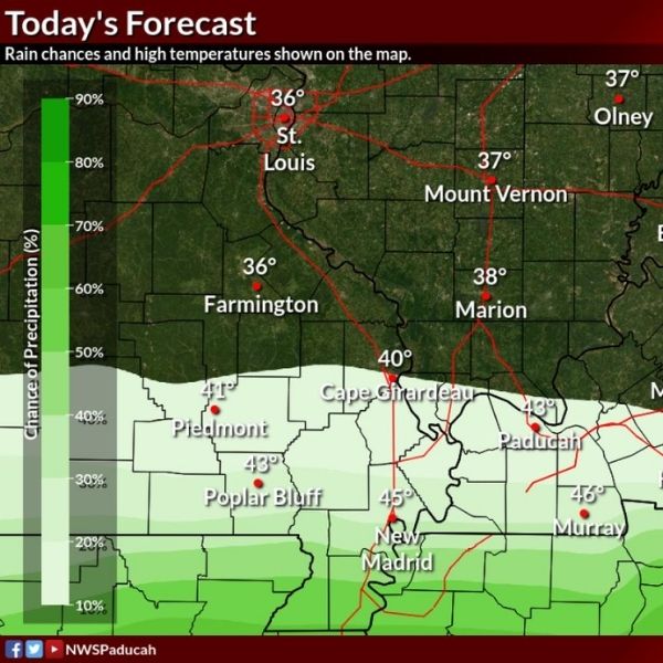
Dry and seasonably chilly conditions will continue through the weekend. Daytime highs will mostly range from the upper 30s to mid-40s, with overnight lows dipping into the 20s and lower 30s.
Early Next Week:
The pattern shifts quickly starting Monday as warmer air moves into the Ohio and Mississippi River valleys. Highs are expected to rise 15–20 degrees above normal, with many locations reaching the lower to mid-60s on Tuesday and Wednesday. Some spots in western Kentucky, the Missouri Bootheel, and southern Illinois could approach or briefly exceed daily record highs.
Rain Chances:
Dry weather will persist through at least Tuesday. A small chance of rain may develop late Wednesday, followed by a better chance for widespread showers Wednesday night into Thursday. Forecast confidence suggests rainfall could exceed one-quarter inch, though severe weather is not expected.
Today and Tonight:
Before the warm-up, a weak disturbance may bring light rain near the Missouri-Arkansas and Kentucky-Tennessee borders. Rainfall amounts are expected to be minimal, generally under one-tenth of an inch, with little impact.
Residents are encouraged to enjoy the mild weather next week but remain aware of changing conditions as rain chances return. The sharp contrast from recent cold could also increase snowmelt and create wet ground in some areas.
More updates will be provided as the midweek rain system approaches.


Leave a Reply