Hurricane Melissa has become so powerful that National Oceanic and Atmospheric Administration (NOAA) Hurricane Hunters were forced to abort their flight mission early Monday morning after encountering extreme turbulence inside the storm.
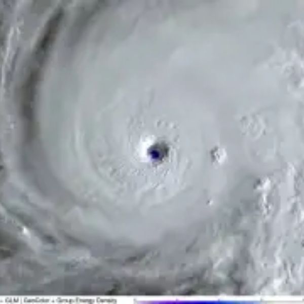
The Category 5 hurricane, with sustained winds reaching 175 mph, is now bearing down on Jamaica, where catastrophic and life-threatening damage is expected as the storm approaches landfall on Tuesday, according to the National Hurricane Center (NHC).
“Melissa is expected to reach Jamaica and southeastern Cuba as an extremely powerful major hurricane and will still be at hurricane strength when it moves across the southeastern Bahamas,” the NHC said in its latest advisory.
NOAA Aircraft Forced to Exit Hurricane Melissa
On Monday, both NOAA and Air Force Reserve Hurricane Hunter crews entered the storm to gather crucial data about its structure and strength. However, the NOAA WP-3D Orion aircraft, nicknamed “Kermit,” had to exit early after facing severe turbulence inside Melissa’s southwestern eyewall.
“The NOAA aircraft left the storm early after experiencing severe turbulence in the southwestern eyewall,” the NHC reported.
The mission’s early termination highlights just how intense Melissa has become — with turbulence levels rarely seen even in the most violent hurricanes.
Meteorologist Ryan Kudish commented on X (formerly Twitter):
“Very rare — the hurricane hunters had to leave Hurricane Melissa early because of severe turbulence in the southern eyewall. Shows the power this storm has with it.”
Melissa’s Impact on Jamaica and the Caribbean
Forecasters warn that Jamaica will face devastating flooding, destructive winds, and deadly storm surge as Melissa moves closer.
Residents are being urged to shelter in place and avoid going outside under any circumstances.
“Jamaica: Do not venture out of your safe shelter,” NHC meteorologists said in a statement.
Melissa is expected to dump 15 to 30 inches of rain across Jamaica, with isolated areas seeing up to 40 inches. Southern Hispaniola could see 8 to 16 inches, leading to catastrophic flash flooding and numerous landslides.
Storm surge will be another major threat:
-
Jamaica: 9–13 feet above ground level, with large and destructive waves.
-
Southeastern Cuba: Up to 11 feet above normal tide levels late Tuesday into Wednesday.
Experts Warn of a Humanitarian Crisis
AccuWeather Chief Meteorologist Jonathan Porter warned that the aftermath could spark an “extremely urgent humanitarian crisis.”
“People choosing to ride out the storm in unsafe areas, or those who are unable to move out of harm’s way, will face great peril,” Porter said. “The devastation from the electricity infrastructure alone may take months to repair. Food refrigeration and safe drinking water may not be available for an extended period.”
What’s Next
Melissa is projected to make landfall in Jamaica on Tuesday, then move toward southeastern Cuba and the Bahamas by midweek. Even before landfall, the storm’s outer bands are already producing life-threatening conditions across Haiti and the Dominican Republic.
Residents in the storm’s projected path are urged to complete all emergency preparations immediately and stay indoors until officials declare it safe.
This article has been carefully fact-checked by our editorial team to ensure accuracy and eliminate any misleading information. We are committed to maintaining the highest standards of integrity in our content.


Leave a Reply