SOUTHERN UNITED STATES — Monday, April 27, 2026, is shaping up to bring a significant round of severe weather across parts of the South and the lower to mid-Mississippi Valley, with the potential for damaging winds, large hail, and a few strong tornadoes.
A dangerous combination of storm ingredients
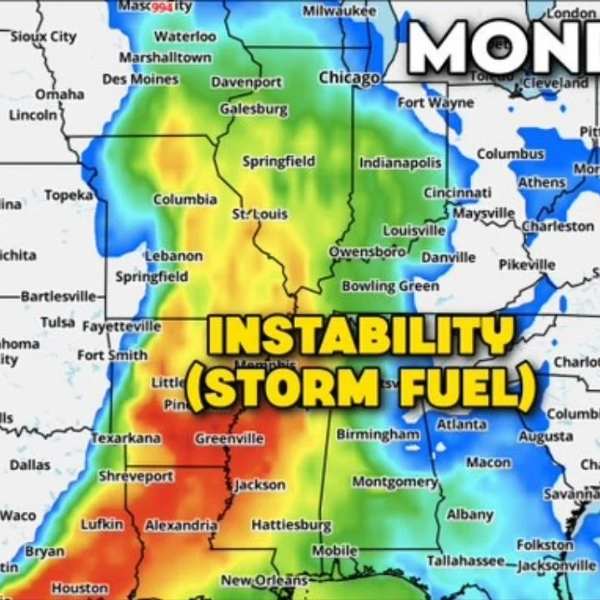
Meteorologists point to a powerful setup driving this threat. A low-pressure system moving through the Corn Belt and Upper Midwest is pulling warm, humid air northward, creating moderate to high atmospheric instability — a key ingredient for severe storms.
At the same time, a strong subtropical jet stream overhead will generate intense wind shear. As thunderstorms develop and interact with these changing winds at different heights, they can begin to rotate, increasing the likelihood of tornado-producing supercells.
Where the highest risk is expected
The greatest concern is focused along the lower Mississippi Valley, particularly near the Arkansas, Mississippi, Tennessee, and Kentucky border region.
- Greatest tornado risk: Eastern Arkansas, Mississippi, western Tennessee, western Kentucky — potential for EF2+ tornadoes, damaging winds, and large hail
- Severe storms possible: Southern Indiana, Illinois, southeast Missouri, Alabama — damaging wind gusts, isolated large hail, and a few tornadoes
Hazards expected Monday
- Potential for significant tornadoes (EF2 or stronger), especially in the highest-risk zone
- Scattered damaging wind gusts
- Sporadic large hail
- Development of rotating supercell thunderstorms
Who should stay alert
Residents across eastern Arkansas, Mississippi, Alabama, western Tennessee, southeast Missouri, Illinois, southern Indiana, and western Kentucky should closely monitor forecasts. The risk level is increasing as the system approaches.
Timing still evolving
Forecasters say details on timing and storm development will become clearer closer to Monday, with more refined updates expected by the weekend. However, the overall pattern already signals a potentially dangerous setup.
Residents are urged to prepare in advance — identify a safe shelter, ensure access to multiple alert systems, and stay updated as conditions evolve.


Leave a Reply