After several days of record-breaking warmth that made much of the country feel more like late spring than late March, meteorologist Max Schuster says the atmosphere is about to shift again—and this next system could deliver a much broader and more unusual mix of weather than many expect.
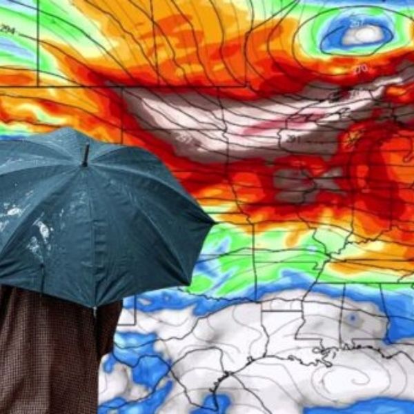
In his latest forecast on Max Velocity – Severe Weather Center, Schuster explains that the jet stream is beginning to reload, a change expected to drive a new storm system across the central United States later this week. He emphasizes this will not be a routine late-March setup, but rather a classic transition-season pattern capable of producing severe storms, heavy snow, sharp temperature swings, strong winds, and even fire danger—all within the same system.
This isn’t just a single front moving through. Instead, it signals a broader atmospheric reset that could bring winter conditions back to some areas, maintain summerlike warmth in others, and set up a more unstable pattern heading into early April.
The Heat Wave Is Easing in Some Areas, But Not Everywhere
Schuster says the country is now moving out of an “unbelievable” heat wave that has already broken more than 300 daily temperature records over the past five days. The warmth stretched as far east as Maryland and Ohio, which is unusual for March. He adds that March 2026 could end up as the warmest March on record in the United States, with temperatures averaging about eight degrees above normal.
While parts of the East and Ohio Valley have already cooled down behind a cold front, with temperatures dropping into the 30s and 40s, the West and Southwest remain locked in persistent heat. Areas like Arizona and California are expected to stay warm for at least another week, possibly longer.
This temperature contrast is helping fuel the next storm system.
The Jet Stream Shift Will Drive the Next System
Schuster highlights that the jet stream is about to dip south again, which is key to the developing forecast. This shift is expected to help form a low-pressure system over the Rockies that will strengthen as it moves east.
While the exact intensity remains uncertain, Schuster says conditions are becoming favorable for scattered severe weather across parts of the Midwest and Ohio Valley by Thursday. He stops short of calling it a major outbreak but notes the setup could quickly intensify if key elements align.
Thursday Expected to Be the Most Active Day
According to Schuster, Thursday and Thursday night are the main periods to watch. By then, the storm system should be more organized, with Gulf moisture, sunshine, and instability combining across the Ohio Valley.
The primary threats include large hail and damaging winds. However, Schuster does not rule out isolated tornadoes, especially if wind patterns strengthen and provide more rotation for storms.
He also notes that these types of setups can be deceptive—appearing moderate at first but still capable of producing impactful weather.
More Than Just Thunderstorms
Schuster stresses that this storm will not only bring severe weather. Strong winds behind the system could impact parts of the Plains and Midwest, potentially causing travel disruptions, blowing debris, and increasing fire risk in dry areas.
Different regions will face different hazards. While the Ohio Valley may deal with storms and possible tornadoes, the Plains could see heightened fire danger due to dry and windy conditions.
Snow Could Return Briefly
Another notable feature is the chance of snow on the backside of the system. Schuster says parts of the Midwest and Ohio Valley—including cities like Columbus, Indianapolis, and Kansas City—could see light snowfall by Friday.
He does not expect a major winter event in those areas, but colder air moving in behind the system makes snow a possibility. He adds that heavier snowfall is more likely in northern regions such as Michigan.
A Brief Calm Before More Activity
After the storm moves out, Schuster expects conditions to settle temporarily. Friday may still bring scattered showers, but a strong high-pressure system should bring calmer and cooler weather by Saturday.
This period will offer a short break, with comfortable conditions across parts of the South. However, Schuster warns the calm will likely be brief.
Early April Could Turn More Active
Looking ahead, Schuster says the overall pattern suggests a more active start to April. With high pressure building in the East and a trough forming in the West, conditions could favor multiple storm systems moving across the Plains and into the Ohio Valley.
He advises people to stay alert and ensure they can receive weather warnings, as the setup may lead to repeated rounds of severe weather.
A Clear Seasonal Shift
Overall, Schuster’s forecast highlights a significant transition. The extreme warmth is easing in some areas, while others remain hot. A powerful storm system is expected to bring a wide range of hazards, followed by a brief cooldown before activity ramps up again.
The contrast across regions—ranging from near-summer heat to potential snow—underscores how dynamic this period will be.
When Schuster says this next storm will “hit differently,” it reflects a pattern that is rapidly evolving and becoming more volatile as the season shifts toward spring.


Leave a Reply