Strong to severe storms are expected late Sunday, followed by falling temperatures and snow showers.
LOUISVILLE, Ky. —
A fast-moving storm tore northeast across the Louisville area, bringing wind gusts reaching up to 80 mph at times.
Shortly after midnight, more than 11,000 customers lost power.
Did you experience storm damage? Send your videos and photos to our Facebook page or upload them to our website.
Here are updates on how the storm unfolded:
TIMELINE:
12:54 p.m. – Most warnings have ended in the Louisville area as the storm pushes toward the north and east, including Lexington and northern Kentucky. Remain alert for strong winds to the south.
12:35 p.m. – More than 11,000 customers are now without power across the WLKY area.
12:18 a.m. – Areas west of I-65 are mostly clear. Around 5,000 customers remain without power across the region.
11:50 p.m. – Storms have already cleared several western areas, but they are intensifying in Louisville. Stay safe.
11:35 p.m. – Storms move toward Shepherdsville and Radcliff. Take shelter.
11:15 p.m. – The storm enters Hardin County, Kentucky, with winds reaching 75 mph.
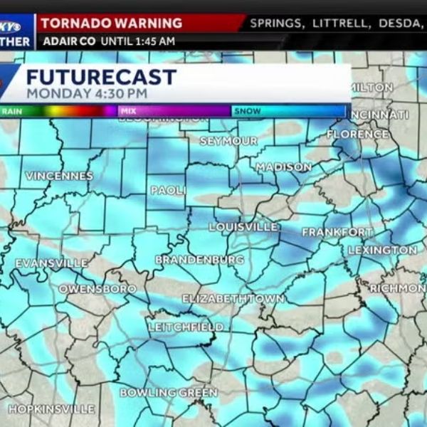
11:06 p.m. – A potential tornado is reported near Leitchfield as the storm races northeast.
10:55 p.m. – A fast-moving storm triggers tornado warnings in western counties.
Here’s what to do if you lose power during severe weather
Once the front passes, temperatures will drop sharply into the 30s, with wind chills falling into the 20s by Monday.
Plunging temperatures
There is also a chance of passing flurries on Monday as cold air moves into the region.


Leave a Reply